|
Back in late 2022 we had planned a trip to western Victoria to visit the desert national parks and also see some silo art. However, record rainfall caused floods throughout the whole state and we had to abandon that plan. This trip is the follow-up to that plan.
The trip was again organised by Ron who was travelling with his wife Donna in their Toyota Land Cruiser 200 series with their new Vista caravan/camper. I was in my Land Cruiser 200 with my Black Series camper trailer.
The following is a map produced from the track recorded by my Hema software on a tablet and exported to Google Earth.
 |
| A map on Google Earth showing our trip. Starting at Sydney far right, then towards left and anti-clockwise up, to the border and down and eventually back the same way. |
Day 1 â Thursday 7 November 2024 â Sydney to Kohlhagans Beach, Wagga Wagga
I wake at 6:00 am, depressed that Donald Trump has won the US election. How stupid can they be to re-elect him after all the problems the first time around? Anyway, I leave just before 7:00 am. It is overcast and a warm 23°C. I head south on the Princes Highway and cut across on Picton Road to the Hume Highway.
Once again I have a problem. It seems to be related to the DPF and has only ever happened when doing more than 100 km/h and where I am going up a steepish hill. The dash shows numerous error messages and the cruise control cuts out. I clear these with my Scangauge but the bigger problem is then that the gearbox will not change into fifth or sixth gear. The only way I have found to fix this is to stop, turn off the engine for at least four seconds. It then works okay.
This problem does not seem to happen when travelling less than 100 km/h. It will happen again on this trip a few more times on the Hume Highway but does not happen again till I am back on the Hume in almost two weeks. It also seems to mostly need a DPF that is nearing full (that is, before it burns off). It has never happened when not towing.
At 8:40 am I arrive at McDonalds Sutton Forest (138.5 km) where I order breakfast. Ron and Donna arrive about 15 minutes later, there has been road problems after Campbelltown. We leave at 8:27 am but stop shortly after as Ronâs tyre pressure sensors are constantly beeping. He adjusts the warning pressure a few times and finally gets it right.
After more DPF problems where I have to stop, turn off the car and start again, we arrive in Gundagai at 12:02 am. This is 374.4 km from home and it is a nice 25°C and overcast. On the way it hit 29 and then it rained and dropped to 21. We go for a walk up town and look at the famous Niagara Café which was closed the last two times we were here. After this we have lunch in the park opposite the information centre (which is closed as it is being renovated).
 | 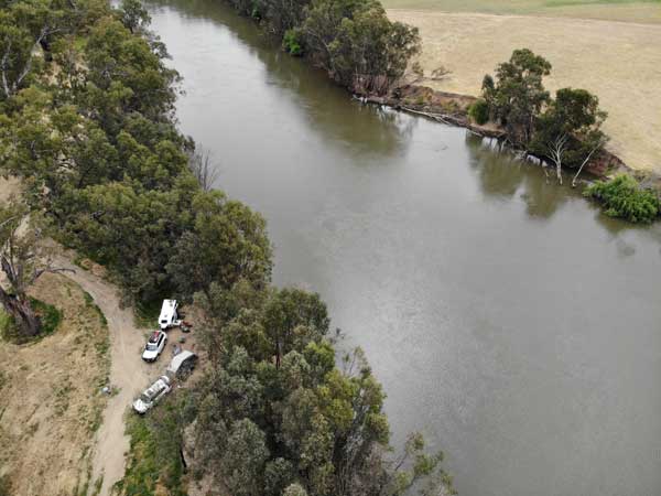 |
| Mural on the wall of the Elders building | A drone shot of our campsite at Kohlhagens Beach |
We leave at 1:05 pm and south of town we turn onto the Sturt Highway. Once on this I have no more problems as the terrain is flat and also we are going slower at about 90 km/h. We arrive in Wagga Wagga at 1:58 pm and stop at one of the first fuel stations as diesel here is much cheaper than the ones in the middle of the city. We have travelled 453.6 km.
We refuel, I take 74.07 litres at 157.9 cents, total cost $116.96. The computer says 14.6 l/100 km but my calculations show 16.0. This is high, probably because I have been driving in fourth gear a fair bit since I need to find a safe spot to stop to turn off the engine. Strangely, the price of fuel here is 20 cents cheaper than most Sydney prices, how can that be when it has to be trucked from Sydney or Melbourne?
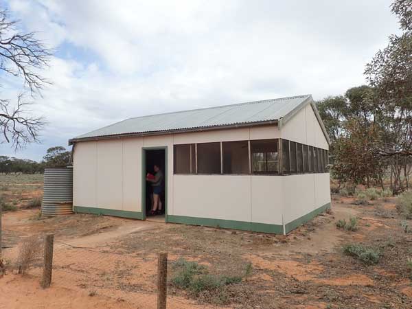
Once refuelled, we head off and at 2:36 pm we arrive at Kohlhagans Beach. This is a free camping area west of Wagga and on the Murrumbidgee River. There are two permanent camps set up here (why doesnât council move them on, they have been here for years). We setup just past the first one. It is now a nice 22°C as I have afternoon tea. We later go for a walk to the end, 630 metres from us. There is only room for a few rooftops there, but there are nice grassy areas between us and the other permanent camp. We also collected some firewood as we walked.
We are back at 4:20 pm and I fly my drone to get some photographs. At 5:00 pm we start a fire and have drinks and nibblies. It is a bit cooler now and we also get some spits of rain on and off. I later cook garlic prawns (from Aldi) and heat some garlic bread for the three of us. A nice dinner to start off the trip. A wine, port and chocolate ends the night. I go to bed at 8:45 pm.
Weather: Overcast with some rain, max 29°C Arrived: Kohllhagans Beach Time: 2:36 pm Distance: 477.5 kilometres
Day 2 - Friday 8 November 2024 â Hohlhagans Beach to Lake Boga
Weather: Overcast, 8.9°C minimum
It was a cool night, I needed my doona but it was still in the car. Not too bad, but I move it into the camper. I wake at 6:20 am and read the SMH via my tablet. I also listen to the 7:00 am ABC Radio news on my brand new radio. Much better than my old one. I get up at 7:20 am and have breakfast. We then pack up. When we leave at 8:50 am, it is sunny and 15°C.
 |  |
| Roo and emu sculptures coming into Lockhart | Tractor sculpture |
 |  |
| Stagecoach | Carriage |
We go back to the Sturt Highway and a short distance west we turn onto Lockhart Road. At 9:25 am as we come into Lockhart, we stop at some sculptures on a private property. These are a kangaroo and joey and an emu, both made from cars. I remember seeing these back in 2012 when returning home from a Murray River trip. This is 47.0 km from our campsite.
 |  |
| The water tower mural in Lockhart | The former Blue Bird Cafe in Lockhart |
We then move to the sculpture trail. This is quite extensive, with a walking track around them all. There are stagecoachs, sheep, roos, swaggies and more. We leave at 9:52 am but stop in town at a park with toilets. We later find there are more toilets down the main street a little (next to the water tank) and more on the other side of the town. Anyway, we walk to the water tank as it has a mural on it. One aim of this trip is to visit a lot of silo and water tank art. There is also more sculptures here of a horse, emus and cockatoos.
 |  |
| Hotel and Grain Merchant buildings | Another old shop in Lockhart |
Ron and Donna walk to the shops looked to get fresh bread (but did not get) and I have morning tea. On the way out we stop at a motorbike sculpture. We finally leave at about 10:50 am. We stop at Urana at 11:20 am to look at a large spider on a water tank. We have head headwinds since we left so we have a relatively high fuel consumption of 14.9 l/100 km. We are only stopped for a couple of minutes. We arrive in Jerilderie at 12:05 pm and we are still heading into the wind. This is 153.4 km from our campsite.
 |  |
| The sign for Lockhart at the sculpture trail | The spider on the Urana water tower |
Jerilderie is famous for its connection to bushranger Ned Kelly. Back in 1879 he and his gang robbed the Bank of NSW and took all the patrons of the Royal Mail Hotel hostage. He then burnt all the mortgages from the bank (did not achieve anything as the head office in Sydney had copies) and wrote his Jerilderie Letter which set out his grievances.
He later let everyone go. Of interest, it is believed that Australiaâs most famous solder, Sir John Monash, met Kelly either then or the year before. Monash grew up here and often said he met Kelly. It is most likely that it was the year before when Kelly sold some horses to Monashâs father. Monash would lead the battles in the Western Front during World War I.
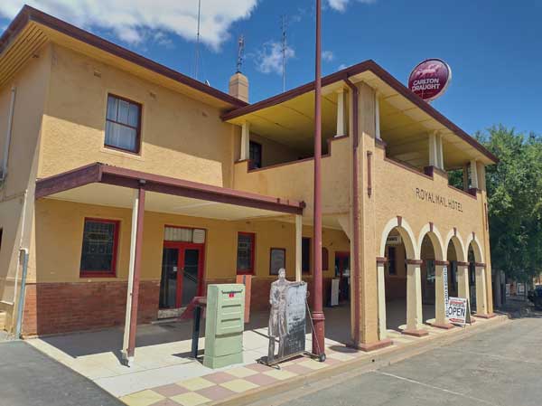 |  |
| The Royal Mail Hotel | Me having a beer with Ron in the hotel |
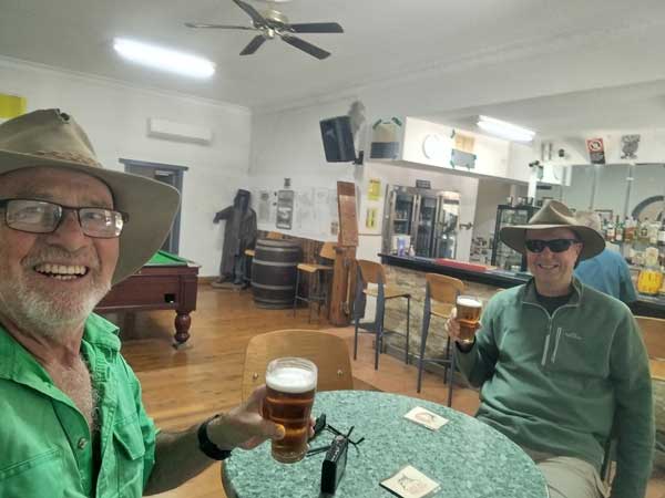
On two previous trips through here I have attempted to have a beer in the Royal Mail Hotel but was unsuccessful. Once it was too early and the other time it was closed as the owners were away. Anyway, it looks like I will fail again today as the sign on the door says closed. However, when I walk past I hear voices inside and so I try the door. Yes, it is open says the owner and it appears she forgot to change the sign.
Ron and I have a schooner ($8) and then we buy a pie from the bakery ($5). We have this at the park and at 12:50 pm we leave. It is a nice sunny 21°C. We travel via Conargo Road through Conargo to Denilquin and then Barham Road to Barham. We cross the Murray River into Victoria. We then take the Koondrook-Murrabit Road and then a variety of roads till we get onto the Murray Valley Highway just south of Lake Boga.
 |  |
| The Lake Boga Silo Art | Our campsite at Lake Boga |
We go to the caravan park and pay our money, $15 a vehicle. We are not staying here, but at the campsite on the other side of the lake. We then go to the silos where there is some art. We have also been told about the Catalina Museum. We drive there but it is just closing (4:00 pm). More about this tomorrow.
 |  |
| A drone shot of our campsite at Lake Boga | A drone shot of Lake Boga, campsite bottom right |
We arrive at the camping area at 4:10 pm. The wind is fairly strong from the west or south-west, coming straight across the lake. We find a spot where we are somewhat protected from the wind by bamboo. We set up camp. It is also close to the toilets which also have showers.
 |  |
| The Lake Boga shore | Sunset over Lake Boga |
At 4:40 pm I have a nice hot shower and at 5:00 pm we have drinks and nibblies in the protection of Ron and Donnaâs van. It is too windy for a fire. Later I heat up some Indian takeaway I brought from home and some more garlic bread. I go to bed at 9:00 pm. It is 17°C but feels more like 10°C because of the wind.
Weather: Fine, max 21°C Arrived: Lake Boga Time: 4:10 pm Distance: 384.0 kilometres
Day 3 - Saturday 9 November 2024 â Lake Boga to Mount Crozier
Weather: Overcast, 7.3°C minimum
At 3:00 am I heard people partying somewhere. I think it was locals drinking on the lakeâs edge a bit further around. Was not too bad, but I could hear them. I wake at 5:20 am and read the paper. I get up at 7:35 am. There is no wind, it stopped before I heard the party. I have breakfast and pack up. We leave at 9:05 am and drive to the Catalina Museum which is now open.
 |  |
| The World War II ramp, still in use | The Catalina Museum |
It costs $15 for seniors to enter. During World War II a flying boat maintenance base was established here. It was a long way from the ocean, so too remote for the Japanese to attack. There were two ramps build to retrieve the planes, hangers, repair buildings and more. There was even an underground communications bunker constructed.
 |  |
| Consolidated Catalina in the museum | An Army Ambulance |
Inside the museum a short talk is given and then a video is played. This is well done and put together by the volunteer team. It explains the history etc. After this we have a look around. There is a Consolidated Catalina PBY5 flying boat, the main plane that was serviced here, as well as things like a Jeep, 1942 Harley Davidson WLA and a Rolls Royce Merlin V12 aircraft engine in running order. There are also a lot more interesting things to see. It is well worth visiting, a bit of history I did not know about. The museumâs website is www.flyingboat.org.au.
 |  |
| Rolls-Royce Merlin V12 engine | The door to the underground communications bunker |
After the museum Ron and Donna have a coffee in the café and I have a cuppa at my camper. One of the original flying boat ramps is now used as the boat ramp, it is still in excellent condition after over 80 years! We leave at 11:22 am and head north-west via Swan Hill and then Chillingollah Road to Chillingollah. This road is a good one or two lane tar road.
 |  |
| Inside the underground communications bunker | Concrete mooring blocks recovered from the lake |
From here take Springfield Road to Chinkaook where we arrive at 12:27 pm. We stop at an old horse trough where we have lunch. This town has seen much better days, that is for sure. The horse trough is one of over 700 that were donated all over Australia from 1927 on. They have been called Bills Horse Troughs as the money came from a trust set up after the death of George Bills. George and Annis Bills had no children and decided to leave some of their money to âfor the relief of horses and other dumb animalsâ. There is one at Como near my home and we see a few others on the trip, including at Dimboola.
Anyway, we have lunch here, lots of flies are around. It is overcast and 21°C. We leave at 1:00 pm. We travel via the Chinkapook-Mittyack Road to the Calder Highway and then follow this north to Ouyen, arriving there at 1:50 pm (153.7 km). We stop here to refuel (84.52 litres at 172.7 cents total $145.97, 14.8 l/100 km) and then at the bakery. Here Ron and I buy a couple of vanilla slices for later consumption. Turns out they are very good. I have half of one for morning and afternoon tea over the coming days.
|  |
| The World War II ramp, still in use | The horse trough in Chinkapook |
We leave at 2:00 pm and head west out of town a short distance and then take McIntrye Road to the North West Road. As it turns out, we could have headed north out of town to here and it would have been quicker. Anyway, from here we turn left onto Curram Road and then when it ends onto Galah North Road for a very short distance. This leads to Honeymoon Hut Track.
 |  |
| Dropping tyre pressures on the Honeymoon Hut Track | Looking straight down at the Mount Crozier camping Area |
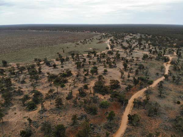
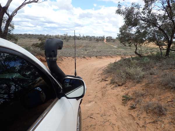
After a while the good dirt road becomes sand. It is now just two wheel tracks and goes over small sand dunes. At 2:50 pm we pull over as the sand is getting softer. We lower our tyre pressures to 25 psi. We are back underway at 3:11 pm. We follow the same track for a long time, past Mopoke Hut Track (another part of which we will be on in two days time) then we turn right onto Mount Crozier Track. Some of the sand on this track is very soft, but we have no problems even towing the vans.
 |
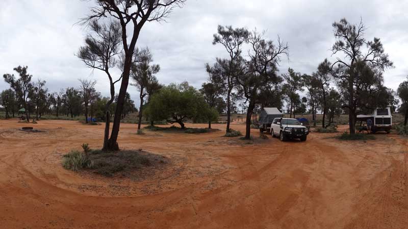
| Our campsite at Mount Crozier |
We arrive at Mount Crozier Camping Area at 4:05 pm. I have averaged 16.1
l/100 since we dropped our tyre pressures. We look around and find a nice spot at the southern end of the camping area. There appears to be only one other vehicle camped here but they are not there at the moment. We set up camp and collect some firewood, there is lots around.
 |  |
| Looking towards Mount Crozier | Looking south-east from the Mount Crozier camping Area |
I then fly my drone and at 5:10 pm we start the fire and have drinks and nibblies. I later cook some sausages, sweet potato and onions on my skillet. We sit around as it gets dark and in the clear skies we see well over 40 satellites, by far/ the most I have ever seen on a camping trip. Of these, one was a newly launched Starlink satellite series (very close together, I counted it as one) and a lot were some Starlink satellites which were more spread out but evenly spaced on the same trajectory.
I go to bed at 10:10 pm, it is 14.8°C.
Weather: Overcast mostly, max 21°C Arrived: Mount Crozier Camping Area Time: 4:05 pm Distance: 231.8 kilometres
Day 4 - Sunday 10 November 2024 â Mount Crozier to Mount Crozier
Weather: Fine, 8.1°C minimum
I sleep very well except for a short time around 3:00 am. I wake at 7:00 am and get up at 7:45 am. I cannot read the paper this morning as there is no internet here. I have a bacon sandwich for breakfast and then make my lunch as we are leaving the campers here and doing a tour.
 |  |
| Stopped to look at wildflowers on the Mount Crozier Track | Another stop on the track |
We leave at 9:30 am and head back to the Mount Crozier Track. We head west on it and then take Underbool Track further west. At 9:55 am we have to stop for Donna to take the obligatory wildflower photographs. We drop the tyres a bit more I think as the sand is softer. The track turns south and we take Grub Track and head east.
 |  |
| These strange "droppings" are all along the tracks, what are they from? | One of the wildflowers along the track |
We have plenty more stops and at 11:00 am we stop again. We have travelled 30.8 km in 90 minutes. I have a cuppa and half of one of the vanilla slices. Yum! We leave at 11:06 am and then stop at Clay Lake which is mostly dry. Here I get some phone coverage so I download the Sydney Morning Herald to my tablet. Past here we cross a dry lake and further on the track becomes Pioneer Track. There is a small salt lake here with a wheat farm before and after it.
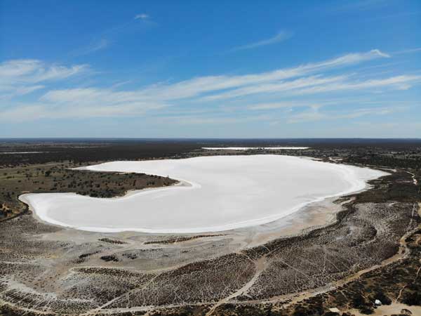
The Pink Lakes are just past here, part of the Murray-Sunset National Park. We take Pink Lakes Road north and stop at Lake Hardy. This is a pink lake, the salt has some sort of algae that gives it the colour. This one is a very light pink, hardly obvious. We walk to the edge and take some photos. We then drive the short distance to Lake Crosbie which is a bigger one. This has a camping area as well. We stop here at 12:27 pm, 52.8 km travelled in the past three hours. It is a nice 25°C and there are lots of flies.
 |  |
| A pink lake, Lake Hardy | The remains of the salt mining operation |
We have lunch here and I also fly the drone. This lake also is not very pink, probably less than the first one. The lakes were used for salt production till 1979. We leave at 1:22 pm. Just a short distance along off the edge of the lake are some remains of the salt mining. We stop and have a look. There is also a pile of salt that was obviously never taken away.
We get back onto Pioneer Drive and head east till we meet Mount Crozier Track again. We follow this to the north. It is quite sandy, possibly more than the tracks we have already travelled. At 2:07 pm we arrive back at the Mount Crozier Camping Area. I have afternoon tea and read the newspaper while laying in my hammock. Three vehicles come in later and camp between us and the entry track.
 |  |
| A drone photograph of Lake Crosbie | Looking down at the Lake Crosbie Camping Area |
We put the fire on at 4:00 pm as tonight we are having roast dinners. We have showers using Ron and Donnaâs shower. At 5:10 pm Ron puts his pork on and at 5:40 pm I put my beef on. The vegetables go on ten minutes later. It is still quite warm as we sit having a drink. The roasts are cooked by 7:00 pm. They are both excellent.
We do the washing up and sit by the fire, but tonight there are no stars or satellites as there is a high overcast. I go to bed at 9:50 pm.
Weather: Fine, max 27°C Arrived: Mount Crozier Camping Area Time: 2:07 pm Distance: 9.1 kilometres
Day 5 - Monday 11 November 2024 â Mount Crozier to Rocket Lake
Weather: Overcast, 13.0°C minimum
I sleep very well except again around 3:00 am when I am awake for a while. Like yesterday, I then sleep till 7:00 am. I listen to the ABC News on my new radio, I am really happy with its performance. I get up at 7:30 am and have breakfast. We pack up and leave at 9:00 am. It is now 19°C.
We head off the same as yesterday but when we get to Underbool Track we head north. We had a few concerns yesterday that we might have had problems towing on this section but it was quite easy. Underbool Track is much better than the first section of track. When we get to Last Hope Track we turn right. This is a sandier track. We get to Mopoke Hut Track at 10:20 am, 40.1 km.
 | 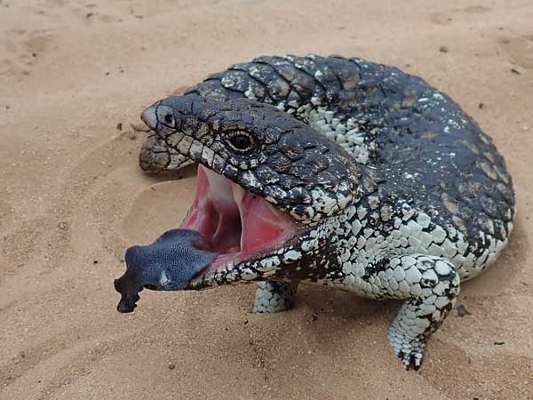 |
| Mopoke Hut | One of many shingleback lizards we saw on the trip |
We arrive at Mopoke Hut, which also has a camping area, at 10:50 am. This is 44.0 km from Mount Crozier, so I have averaged 15.2 l/100 km. The three vehicles from last night are already here even though they left after us, they came up via Honeymoon and Mopoke Hut Tracks. We have morning tea here.
The hut was built in 1962 by Alan Henshke. Interestingly, I used to work with an Alan Henshke, perhaps they are father and son. The camping area here is pretty average, not sure it is worth staying here. It was also dirty with lots of rubbish, some of which we collected.
 |  |
| Part of the track from Mopoke Hut to Rocket Lake | Looking over the dry Rocket Lake |
We leave at 11:15 am and back track to Rocket Lake Track which comes off the intersection of Mopoke Hut and Last Hope Tracks. This track is a very sandy track which goes over lots of small sand dunes. It is easy going despite this. We arrive at Rocket Lake Camping Area at 12:05 pm. This is a small camping area near the dry lake. It has a toilet and some tables.
 |
| Our campsite at Rocket Lake |
Again, the three vehicles from last night are here and staying as well. We set up camp and I put up my fly-proof cabana. It spits a little till 1:20 pm. I have a roast beef sandwich for lunch, leftovers for the next few days! At 2:00 pm we go for a walk to the edge of the lake. This is over a dune to the west. The lake is a dry lake, I am not sure if it ever fills with water.
We then follow the track to the north for a bit and then back track and take another track to the north before returning to the camping area. We get back at 3:00 pm, we walked 2.8 km.
 |  |
| Looking out over Rocket Lake | The Rocket Lake Camping Area |
I have a cuppa and read inside the cabana. It is now hot and sunny. We have a shower using Ronâs shower. We have drinks and nibblies. Later we cook our steaks on my Bidji hotplate, I have a scotch fillet from Aldi. It is excellent. I have it with an Aldi flavoured rice dish.
We later start a fire in the firepit and I later heat us all half a small apple pie with ice cream for dessert. We see eight satellites and I go to bed at 10:20 pm.
Weather: Overcast mostly, max 28°C Arrived: Rocket Lake Camping Area Time: 12:05 pm Distance: 67.4 kilometres
Day 6 - Tuesday 12 November 2024 â Rocket Lake Camping Area to Border Camp
Weather: Overcast, 17.3°C minimum
Another very good nightâs sleep. I wake at 5:35 am as there is some very light rain which continues till 6:10 am. I wake at 6:58 am when I finally get my radioâs alarm to work. I get up at 7:10 am and have breakfast. We have a pretty long day, so we need to leave earlier than normal. We pack up and leave at 8:35 am when it is already 21°C.
Ron heads out and takes a track along the lakeâs edge but my map does not show it joining up with the main track. I take the main one and get to a spot where it looks like a track used to come from the lake, I tell Ron this and he has to find a place to turn around and backtrack. Once they get to where I am, we continue north. We leave the national park 12.4 km from the camping area and are now on Merrinee South Road.
 |  |
| The track north from Rocket Lake | The same track |
When we get to the Maringur-Red Cliffs Road (also called Millewa Road) at 9:36 am (33.7 km) we turn right. We stop just up the road and pump our tyres back up. We leave at 10:05 am and a bit further on I have to stop as my front left tyre is leaking. I obviously have not put the tyre pressure gauge back on properly. I top it up and all is good.
We arrive in Mildura via the Calder Highway at 11:00 am. We go to the fuel station first. I take 48.5 litres at 172.9 cents for a total of $83.80. This is an average of 15.6 l/100 km. I then go to Woolworths for a few things (bread, apple pies, chips and a pack of finger buns).
I also go to BWS and get some sparkling and a cask of white wine. I have morning tea in the carpark while I wait for Donna to finish her shopping. At 12:09 pm we go to the water point which is at the council works depot. From here we go to the park next to the Murray River for lunch.
We leave at 1:08 pm (31°C) and take the Sturt Highway out of town to the west. We stay on this till we reach the South Australian border at 2:36 pm. We have now travelled 211.5 km. We head onto the Border Track which consists of two wheel tracks over the sand dunes. We stop a short distance down and drop our tyre pressures again.
 |  |
| The track along the South Australian Border | The Border Track |
We are back on the road at 2:53 pm. Almost 30 minutes later I spot that there appears to now be a better track running parallel to the one we are on and it appears better. We cross over to it when there is a track joining them. It does turn out to be better and our average speed increases. At Pheenys Track we turn to the east and 150 metres down we turn onto the track to the Border Camping Area.
 |  |
| The old fence is the border between Victoria and South Australia | The better track to the east a short distance |
We arrive there at 4:45 pm, averaging almost 25 km/h at 16.1 l/100 km. It is now a very hot 35°C. We set up camp in this very large camping area (which unfortunately does not have any toilets). We have a cold shower using Ron and Donnaâs shower, very refreshing! We then have drinks (no need for a fire tonight and also too windy). There is a big thunderstorm to the south and some to the west. The BOM rain radar shows it should all miss us and it does.
 |  |
| A drone shot looking south-west at the Border Camp, note the storm in the background | Looking towards the north-west |
I cook some sausages on my stove and heat up some of the rice from the other night. The flies are now gone, they were pretty bad when we got here. I go to bed at 10:00 pm.
Weather: Fine mostly, max 35°C Arrived: Border Camp Time: 4:45 pm Distance: 260.2 kilometres
Day 7 - Wednesday 13 November 2024 â Border Camp to Bill Billy Camping Area
Weather: Fine, 14.8°C minimum
I sleep very well till 6:00 am. There is phone coverage here as there are wheat farms just over the border and a few small towns nearby in South Australia. I read the paper and get up at 7:30 am. It is now 18°C and very windy. I have breakfast and pack up.
When we go to leave I notice that my front right tyre is totally flat. I have to pull out the compressor and pump it back up. I never do figure out why it was flat, all I can think is that the tyre pressure monitor has not been on fully and the air slowly leaked out. Strange though that it had not leaked in the seven hours from when I filled it back up yesterday till we camped.
 |  |
| Coming along the track | Typical section of track |
We leave at 9:17 am and again follow the Border Track south. We stop for some photographs of wildflowers 13.1 km down the track. It looks like it rained here last night as there are some puddles of water. Just under 1.5 km further along we come to a sand dune that is very soft. Ron takes two goes to get over and I take three. I do not have the clearance that Ron has and I bottom out. Second high turns out to be better than third or fourth low.
 |  |
| Another section of the track | The Rockholes |
At 10:15 am we come to a place called the Rockholes, 19.5 km along. There is a sign on the road but inside the fence there is no indication as to where the ârockholesâ are or explaining them. It takes us a while to find it. Turns out it is a large hole about one by two metres in a rock filled with (very dirty) water. Presumably it was an Aboriginal water point. We have morning tea here.
We leave at 10:35 am. It has been very sandy to here then a 2WD dirt track. We take Rock Holes Track, then Braun Road and then Bellbird Bore Road. These are excellent 2WD roads. Once we pass Briscoe Road Bellbird Bore Road changes into a 4WD track with sand dunes. At the end we turn right and then immediately left onto Carina North Road. This is a 2WD road and leads us to Mallee Highway. We turn left and at 11:52 am we arrive in Murrayville. We have travelled 78.6 km and it is a sunny 22°C.
 |  |
| The very colourful toilets at Murrayville | Another of the Bills horse troughs at Murrayville |
We stop in the park opposite the hotel. I have been here twice before, both times when returning from South Australia, in 2021 and 2022. We have a look around town and try to heave a beer at the Murrayville Hotel. It doors are open, but there is no one inside. I finally find someone who gets the owner, but he says the pub is closed. For the life of me I do not understand why he did not get us a couple of beers, would not have taken him more than a couple of minutes.
 |  |
| The Murrayville Hotel | A closed milk bar in the Murrayville main street |
Anyway, we leave town at 12:32 pm and head west on the highway to Ngallo South Road. About 14 km down we come to the boundary of Big Desert National Park. We enter the park on Coburn Track and drop our tyre pressures to 18 psi. We do not have much problems and at 1:33 pm we arrive at Red Gums Camping Area. This is five kilometres from the entrance. I have averaged 40.3 l/100 km since entering the park.
This is not a really great camping area, no toilets and very sandy. It is now warmer at 25°C. We have lunch here and then leave at 2:05 pm. One kilometre from the camping area we come to a sand dune that is problematic. Ron tries twice without success. He drops tyre pressure again to 14 psi. He gets up. I then try (after also dropping pressures) but I keep bottoming out near the top, despite four attempts. Ron and Donna push sand from the middle into the wheel tracks and I then get up.
 |  |
| A typical section of Coburns Track, notice the very soft sand | Red Gums Camping Area |
Then I have problem on a corner which is very soft. We have to use my home made max trax (cut up bread tray) and shovel some sand and I reverse out. Second go I get through. Around here we notice that the national parks people have cleared about a car width on the side of the sand track.
Soon after we come to a quite steep dune which has very soft sand. Ron goes up on the cleared side of the track but then once he hits the top of the dune he cannot see what the cleared area is like ahead of him and he cuts back onto the track too early and his van almost rolls. In the process, his vanâs left tyre pops off the rim.
I then come up and almost make it to the top. I reverse a short way and go again but fall short by about five metres. I get out and go and check on Ron. He will clear under the van and then jack it up and try to pump the tyre up and reseat the tyre bead. In the meantime, I decide to winch myself the last little bit. I put a strap around a tree and then attach a strap to it and lead back towards my car. I then reel out the winch cable and connect to the strap.
 |  |
| Winching myself up the last bit of the hill on Coburns Track | Ron coming up a section of Coburns Track |
I reverse a little, fill in the holes where my front wheels were and then using crawl control and the winch I slowly pull myself to the top of the dune and over. I put all my stuff away and then go and help Ron. By now he has got the tyre off the ground and the pump connected. As the air goes into the tyre, we push and pull the tyre and get a seal and all of a sudden, the tyre reseats itself.
We lower the van, then have to dig out the jack. Finally we are all ready to go. It has taken us about 72 minutes to get up this dune. We leave at 4:08 pm. There is another dune about 30 minutes later that we have to have a couple of goes at, even though we go up the grassy side. We are back underway at 4:47 pm. We follow Coburns Track, which is now much better, till we get to Cactus Bore Track where we turn right and go past the Cactus Bore Camping Area.
 |
| Our campsite at Big Billy |
At 5:25 pm we come to the Nhill-Murrayville Road. We turn right and at 5:44 pm we arrive at Big Billy Camping Ground. We take a while to find a spot, some of the areas are not very level. We finally find a spot and at 6:15 pm we set up camp. We use Ronâs shower to have a very welcome wash, we have sand everywhere and it was very sweaty freeing our vehicles multiple times (I think it was six all up).
At 7:00 pm we have drinks and at 8:15 pm I cook a pork curry and rice using some of the roast pork from a few nights ago. There are a few other vehicles here. This is a nice camping area (except for the lack of flat spots) with toilets, two BBQs and two tables under a shelter shed and more tables elsewhere. We have a nice fire and at 10:15 pm we go to bed. I turn on the radio and there is an interview with Gaynor Wheatley (wife of the late Glen) about John Farnhamâs biography which has just been released. It is very interesting and I listen till it ends at 11:00 pm.
Weather: Fine, max 25°C Arrived: Big Bill Camping Ground Time: 5:44 pm Distance: 147.9 kilometres
Day 8 â Thursday 14 November 2024 â Big Billy Camping Ground to Lake Albacutya
Weather: Fine, 2.8°C minimum
A very cold night and I sleep very well, obviously all the digging etc yesterday was of some use. I wake at 6:30 am. I read my book as there is no phone coverage here to download the paper. I get up at 7:40 am and it is now 8°C. I have a bacon sandwich for breakfast.
 |  |
| A drone shot of Big Billy Camping Area looking south | Looking north from Big Billy Camping Area |
We pack up and pump up our tyres to normal road pressures. We then go for a short walk to a lookout. It is 780 metres return. There are nice views from here. When we return to the cars, I fly my drone. We leave at 10:07 am and drive back to the main road and stop at the Big Billy Bore. We leave at 10:30 am and head south. We soon come across some wildflowers, so we have to stop for Donna to take photos. We stop again a few more times so I decide to go on ahead to Stockmans Camp Camping Area for morning tea. I get there at 11:20 am. This is 32.3 km from Big Billy.
 |  |
| The windmill at Big Billy Bore | Stockmans Camping Area |
This is a small but very well set up camping area, with toilets, water shed, BBQs and tables. I have morning tea here. After an hour, they still have not arrived and are not responding to my UHF radio calls. I drive back and a few kays down the road we make contact. Ron says they will be along soon. I go back to the camping area and have lunch. They finally arrive at 1:15 pm!
Ron has lunch and we leave at 1:53 pm. There are more wildflowers that we stop at. At 2:40 pm we stop as Ron only pumped his tyres to 24 psi and he needs to pump to 40 psi. We are back on the road at 2:56 pm.
 |  |
| Some shops in Rainbow | The King Charles III Hotel at left |
We travel via Yanac and Netherby and at 4:00 pm we arrive in Rainbow. This is a small town with some very nice buildings. There is a newly renamed hotel called the King Charles III Hotel (closed it seems despite the new name) and the Eureka Hotel as well as a cinema. We go to the Eureka Hotel for a beer. The person who serves us is a relieving manager who is very chatty. We discover that the brewery next door is owned by the pub owner (he also owns the shop) but is closed for good probably.
 |  |
| The Rainbow Eureka Hotel | Ron and I having a schooner in the Eureka Hotel |
We leave at 4:39 pm and head north and at 5:00 pm we arrive at Lake Albacutya Camping Area. This is a very large area and there are toilets and cold water showers. We are the only people here so we have the pick of the spots. Unfortunately, we pick a spot where lots of large ants come out of the ground once we set up chairs. I go to the toilet block and have a cold shower. Refreshing that is for sure, but not too bad.
 |  |
| Looking south-east over Lake Albacutya | Looking east over Lake Albacutya |
I fly my drone and at 6:00 pm we have drinks. At 7:30 pm I cook some chicken loins, sweet potato and rice for dinner. We start a fire at 8:25 pm. The flies were bad earlier, I even had to put my fly net on my head. They were gone by 6:45 pm. We go to bed about 10:00 pm, it is 15°C now.
Weather: Fine, max 26°C Arrived: Lake Albacutya Camping Area Time: 5:00 pm Distance: 176.2 kilometres
Click here for the next part of this article.
|  v6.00.307 © 2003-2005

