|
For the previous part of this trip, click here.
WEIPA TO CAPE YORK
Monday 21 August 2000 - Weipa to Dulhunty River
We leave the camping area at 8:45 am but we have to stop to get gas as we could not buy on Sunday (no idea why they would not sell it to us then) and we refuel with 36.5 litres at $35.00. Our fuel economy since leaving Coen is 11.1 litres/100 km.
We reach the Batavia Turnoff (this is a short-cut to the Old Telegraph Line - OTL) at 9:40 am and at 10:52 am we get to the OTL. There are lots of small creeks to cross and I seem to recall seeing the wreck of a caravan along here.
We have morning tea here on an airstrip. We restart at 11:13 am and at 11:46 am we cross the Wenlock River. By 11:58 we are all across. The water was over our bonnet. Only a short distance past the river is the old Moreton Telegraph Station. This has accommodation and some supplies but no fuel.
At 12:53 pm we arrive at Bramwell Station. This is a short diversion off the OTL and has a bar and take-away food (I think there is also accommodation and a camping area). We have a hamburger here. As we leave, we have a problem as the automatic transmission is flashing M, S, D and there is no manual selection in high range.
You go back onto the Gunshot Creek Southern By-pass Road and turn left and shortly after turn right back onto the OTL. It gets very slow from here. Five kilometres along we come to Palm Creek. This is very muddy and it takes us a while to get across.
Three kilometres up the track is Duicy (or Ducie in some books) Creek. There are more creeks, the South and North Alice Creeks and 30 kilometres later we arrive at the Dulhunty River. It is 4:30 pm and it has taken two hours to travel 38 kilometres. By now, Daryl and I have figured out that the problem is caused by the high range/low range selector not being properly in high range. Once we move it around and back into high or low range, everything is working okay.
We travel to a camping spot that a dive buddy has given us. He has told us that there is a good camp site at 11ΒΊ 49' 57"S 142ΒΊ 26' 31"E (using WGS84 as datum I think). This is on the southern side of the river and to the west. We get there are find that it is a pretty average camping site but that is about all that is available as most other sites are taken.
A few of us have a swim in the river after checking that there are no crocodiles (we look in the clear water that is deeper and with shallows and rapids either side). It is very refreshing and makes up for our lack of showers.
Distance: 217 kilometres, Fuel: N/A
Tuesday 22 August 2000 - Dulhunty River to Twin Falls
 |
| Julius examines the route he intends to take to cross Gunshot Creek |
We leave at 8:30 am and once we are back at the OTL we cross the Dulhunty River. It is not all that deep, perhaps up to the top of the headlights. A short distance later we have to stop as John and Norma have a problem with their car. I cannot remember what it was but it was soon fixed. We are back underway at 9:40 am.
At 10:30 am we get to the infamous Gunshot Creek. This is 24 kilometres from the camp site. There are a number of separate approaches to the creek on the south side and all are very steep. Looking north from the south side, the accesses to the creek from the left are as follows:
Very Steep, Intermediate, Very very Steep, Very Steep, Easy, Very Steep.
Julius decides to take the hardest one, the middle one. He has roll-bars all along the side of the car so that if he is a bit off target, these should take the impact. He goes down as slow as he can into the hole (and it looks like a hole) and he does hit the side. He makes it through without damaging his vehicle.
We all take the easy access, although it is still not completely simple. Once down we need to turn left and drive 20 metres along the creek before exiting up on the northern side. It takes us 40 minutes to cross the creek (although I think that we may have had morning tea here as well).
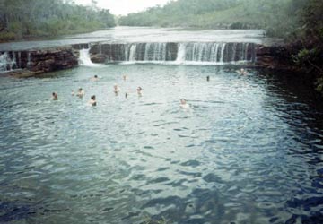
At 11:55 am we are at Cockatoo Creek (10 kilometres along the OTL). The OTL is a bit easier from here and we cross the by-pass road (really a bit of a dog-leg as you cross - left is to the Jardine River ferry). We reach Fruit Bat Falls at 12:40 pm (26 kilometres along). We have lunch here as well as a swim in the pool below the falls. Again, we check for crocodiles before entering the water. The water is crystal clear and so refreshing. While we are here, Julius jumps in the water and injures his ankle. He is now limping badly and his ankle is hurting a lot.
 |  |
| Having a swim at Fruit Bat Falls | Twin Falls |
We leave at 2:20 pm and 15 minutes later we are at the Elliot Creek Picnic Area. We have a walk around and then at 3:20 pm we arrive at the Twin Falls/Elliot Creek/Indian Heads Camping Area (it has heaps of names in various books). We have travelled 72 kilometres today.
We set up camp and then go for a swim in the creek. There are some excellent rapids that make great "spas" and we have a nice massage sitting in the small pools.
There are lots of commercial operations set up here. These are mostly small 4WD buses with about 10 or so tourists. Most appear to be backpackers.
Distance: 72 kilometres, Fuel: N/A
Wednesday 23 August 2000 - Twin Falls to Seisa
We have a late start at 10 am and six kilometres on we cross Turkey Creek. Then there is Cannibal Creek which has a steep exit.
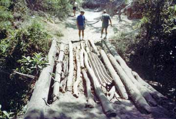
About 9.8 kilometres from Elliot Falls is Cypress Creek. This has a bridge built out of fallen tree trunks and one piece of World War II pressed steel plating (PSP). We need to examine this carefully before we decide which section to drive on. See the attached photographs.
 |  |
| Examining Cypress Creek bridge before we cross | Crossing Cypress Creek bridge |
At 11:42 am we cross Logan Creek (19 kilometres along). This has a steep drop to mud and then a sandy creek. At noon we cross Nolans Brook. This was deep (one metre) and muddy past the exit. Only 1.6 kilometres along is the track off to the left that leads back to the main track to the Jardine River Ferry.
We continue on and at 1:25 pm we come to the Jardine River. This is where vehicles used to cross the river before the ferry was put in. I really would not cross the river at this location considering the depth and current and our vehicle. If I had a 1970 LandRover or LandCruiser, then I would give it a go.
We have lunch here before leaving at 1:46 pm. We back track to the track mentioned before and get back on the main track north. We arrive at the Jardine River Ferry at 3:10 pm. It is $88 to cross the river. This includes the return crossing as well as free camping at all spots north of the river (outside the caravan parks). As far as I know, the price in 2007 is still the same.
Only three cars can be carried on the ferry at a time so it takes three trips to get us all across. It is not far, only a couple of hundred meters at the most. Once again, you would not swim for quids in the river, although there were some Aboriginal kids swimming.
We arrive at Bamaga at 4:08 pm and Seisia at 4:15 pm. We have travelled 107 kilometres today.
We book into the caravan park for three nights at a cost of $52.80.
Distance: 107 kilometres, Fuel: N/A
For the next part of this trip, click here.
| 
 v6.00.307 © 2003-2005