Michael McFadyen's Scuba Diving - Bare Island Deep Wall
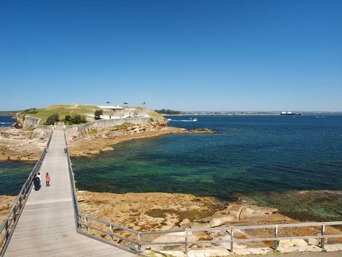 |
A photograph of Bare Island Right on a perfect day
The best entry point is at the far right of the island, to the left and above the rocks jutting out
The exit point is on the island just to the right of the bridge |
In Sydney, the location I have dived most is Bare Island (over 700 dives). There are many dives that you can do here. In this article I will describe another of these dives.
Located 20 kilometres from the centre of Sydney, Bare Island is part of Botany Bay National Park. From the city, travel along Anzac Parade or Bunnerong Road to La Perouse. Upon arriving at La Perouse, park on the edge of Anzac Parade above the island as close to the island's access road as you can. Walk to the edge of the headland overlooking the island to check the water conditions as well as the entry and exit points. This dive can be done in virtually all seas, even those from the south-east. I have dived here many times when surfers have been surfing off the eastern end of the bridge that joins the island to the mainland. It is only in the hugest of seas that you cannot dive this site. One thing that can affect the site is that after prolonged periods of very heavy rain, the visibility can be reduced to one or two metres.
If you asked me back in the mid-1990s I would have said that even at its best, the visibility only got to four or five metres. However, since about 1999, visibility here has improved dramatically. In 2002 I dived here 10 times. The visibility averaged almost 10 metres on these dives which is certainly much better than the previous 13 years. In May 2003 I dived here and had 15 metres and in December 2003, January 2004 and December 2005 I had at least 20 metres on the deeper reef. The tides do not really have much impact on a dive although sometimes an outgoing tide can cause a current in the deep section of the dive. This is normally when there has been a very large high tide. Visibility is sometimes better on high tide but I have also had good visibility at low tide.
 |  |
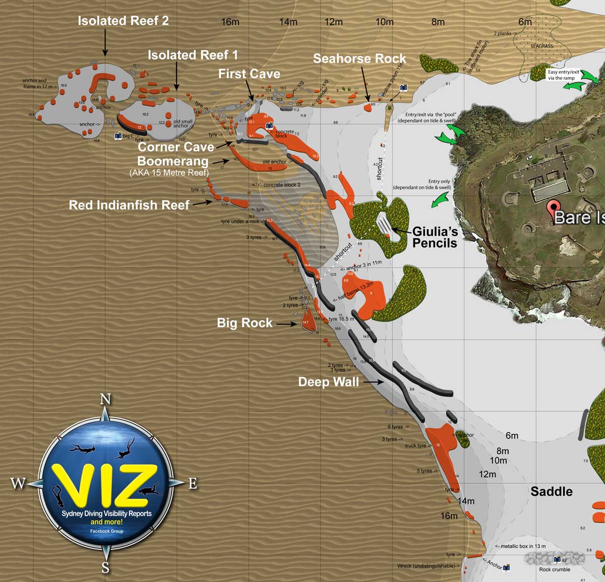
A satellite photograph of Bare Island showing the reef
Entry point is far left of the island | A map of Bare Island (Right)
Click to enlarge |
 |  |
A new underwater map of Bare Island created by Marco Bordieri from www.viz.net.au.
For a much larger pdf version of this map, click here.
Used with permission of Marco Bordieri | Information about the map at left and below |
 |
A new underwater map of the western side of Bare Island created by Marco Bordieri from www.viz.net.au.
For a much larger pdf version of this map, click here.
Used with permission of Marco Bordieri |
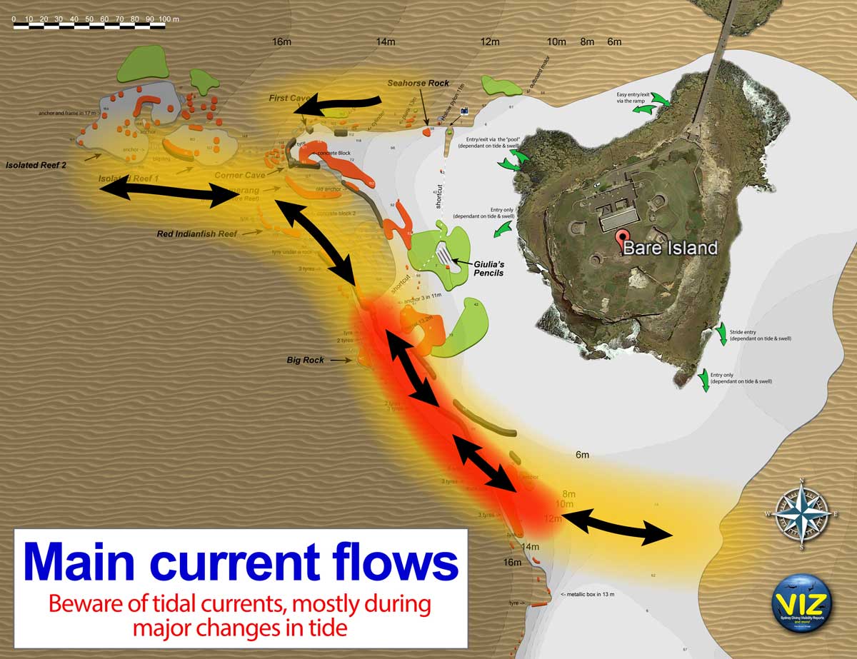 |
This shows the predominant tidal currents at Bare Island. Incoming are the currents to left, outgoing to right. Created by Marco Bordieri from www.viz.net.au using my information.
Used with permission of Marco Bordieri |
BARE ISLAND NOT SO DEEP WALL
Originally I had a different article here describing a number of ways to dive this site. However, in 2026 I revised it to split it into two sections and also simplify the article as well as provide greater guidance to divers before they do their first dive here.
Basically, I recommend that you first do the Bare Island Right dive and then the 15 Metre Reef dive before even attempting this dive UNLESS you are accompanying someone who knows this site very well. If you attempt to do this dive without first doing many other dives on the shallower parts of the reef, you are likely to get lost, run out of air and surface way out in the open water.
PREFERRED STARTING POINT â WESTERN POINT OF ISLAND
 | 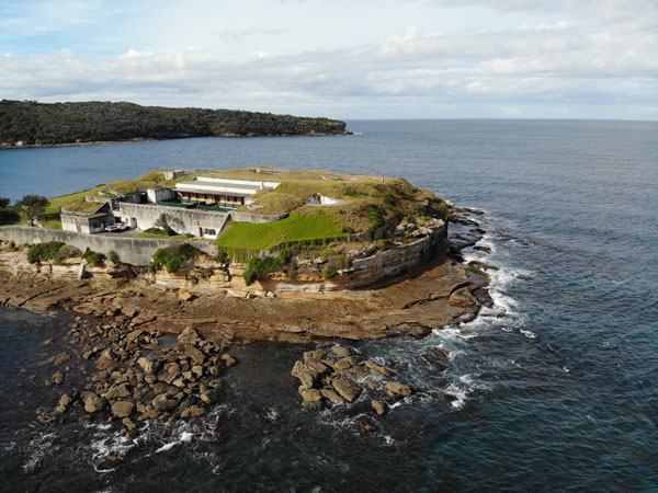 |
| A drone photograph of Bare Island from the north | A drone photo of the north-western corner of the island. The entry point for most dives
is the bottom right corner of the rock platform, the pool entry point is fairly obvious |
Walk out to the far western point of the island and enter the water from the actual point. I would not start here until you have done the dive at least once as per one of the abovementioned dives (or are with someone experienced in doing the dive this way). You must be very good on your air consumption and navigation. You will need extremely calm seas to do this dive (and the following dives) and good navigation skills as you come back a totally different way to how you get there.
Enter the water and snorkel out 10 or 15 metres till the water deepens. After descending, it is fairly shallow (3 metres) and not all that interesting. Head to the west (or just a bit south) and eventually you will reach the sand edge of the main reef at about 14 metres. This takes about four minutes. You will be to the south of the Sea Horse Cave mentioned in the Bare Island Right dive.
There are some large boulders here on the sand. Once you pass them, follow the smaller wall to the north-west. After about 25 or 30 metres you will see off to your left a bit of reef with growth on it. This is 15 Metre Wall. You can either continue along the main section of the wall or head over to the 15 Metre Reef.
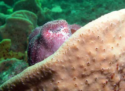 |  |
| A cuttlefish on the Deep Wall hiding in a sponge on the Deep Wall | Pygmy pipehorse on 15 metre ledge |
If you follow the main wall, you will see some overhangs and "inlets" in the reef. Another 30 or so metres will bring you to Sea Horse Corner. As you will have been here before on the Bare Island Right dive, you will be familiar with the spot and the way back to the exit. As a reminder, just follow the reef edge to the north-east and east. It will take about 30 minutes of slow exploring.
Note that this dive will take at least 50 minutes. Divers who are good on their air will be able to do up to 90 minutes. Due to the depth, possible currents and many reefs, it is not for inexperienced divers. Again, I would recommend a large tank.
ALTERNATIVE STARTING POINT â THE POOL
If the seas are a bit too rough for going in off the western point, an option is to walk almost out to the far western point of the island and enter the water in the sort of pool that is formed by the two piles of rocks just inside the actual point. Once in the water, swim out on the surface through the "heads". At low tide, the bottom is very shallow and you may need to haul yourself over the rocks.
| |
| A drone photograph of Bare Island from the north | A drone photo of the entry points for options 2 and 3 to 5
3 to 5 is the bottom right corner of rock platform, 2 is the pool which is fairly obvious |
Once in deeper water, head south a little and then descend and head to the west. Follow the directions earlier.
ALTERNATIVE STARTING POINT â NORMAL SPOT TOWARDS BRIDGE
If you don't want to walk all the way out, you can enter the water at the normal Bare Island Right starting spot. Descend and head to the Shark Fin/Outboard Motor. Then go over the kelp and continue in the normal direction. However, when you come to the first orange sponge on the edge of the sand, veer to the left instead of the right.
This will lead you to The Shortcut. This is a sort of gully that runs south and gets shallower. Once you have past a large rock on your right, go around it and head west. This will be in the same area as the start of the dive from the Western Point.
WARNINGS
Things to be aware of on this dive are:
WHAT TO DO IF YOU GET LOST
First, do not ascend under any circumstances. Same goes if you lose your buddy. If you get lost or lose you r buddy, head north-east and you can never end up totally lost. You will either end up next to the island or on the mainland. Only surface once you are in very shallow water, that is, less than three metres.
SUMMARY
A fantastic dive site, one of the best in Sydney. Now home to pygmy pipehorses, although they can be very hard to find at times.
|  v6.00.307 © 2003-2005


