Michael McFadyen's Scuba Diving - Bare Island Isolated Reefs
 |
| A panoramic photograph of Bare Island on a perfect day |
Readers of my web site are would be aware that I love Bare Island as a dive site. This is where I grew up and since I first started diving, it is the location that I have done more dives than anywhere else in Sydney or NSW or in fact, the whole of the Pacific. The more I dive here, the more I am amazed by what I see, both in terms of the extent of the underwater environment as well as the fishlife.
About 1998 when I had visibility of about 20 metres, I discovered another reef that extended past the end of the normal Bare Island Right (West) dive. I had never been able to see it as before this, visibility was inevitably only five to seven metres as a maximum. Since that time, visibility has been much better. In addition, back then there was a lot more sand in the area while now there are visible rocks that run all the way across from the main reef.
On the map below, this is located where the name "Bare Island" is located. When I first discovered this reef, it took me a few times diving here to rediscover it. I am sure that I am not the first person to have dived this location, but I am pretty certain that I am now the person who dives this spot the most. In fact, there are at least two separate reefs here, both almost connected to each other. If you are very experienced and have done the normal Bare Island Right Dive a number of times, you can try out this very colourful reef which is home to huge numbers of fish.
 |  |
A map of Bare Island (Right)
Click to enlarge | A satellite photograph of Bare Island
The isolated reefs are located in mid left of photo
The entry point is just to the right of the point
which is left of white building upper middle |
Until late 2004, I always accessed this site by following the normal Bare Island Right dive and then going to the north-west. However, in December 2004 I decided to try to see if there was an easier way. There are! Read on to see how to do it either of the four ways.
Located 20 kilometres from the centre of Sydney, Bare Island is part of Botany Bay National Park. From the city, travel along Anzac Parade or Bunnerong Road to La Perouse.
 |  |
A new underwater map of Bare Island created by Marco Bordieri from www.viz.net.au.
This is not yet complete as you can see. For a much larger pdf version of this map, click here.
Used with permission of Marco Bordieri | Information about the map at left and below |
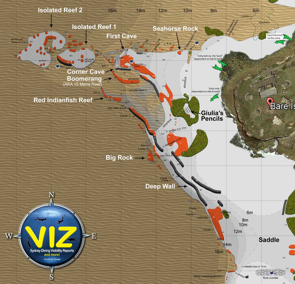 |
A new underwater map of the western side of Bare Island created by Marco Bordieri from www.viz.net.au.
For a much larger pdf version of this map, click here.
Used with permission of Marco Bordieri |
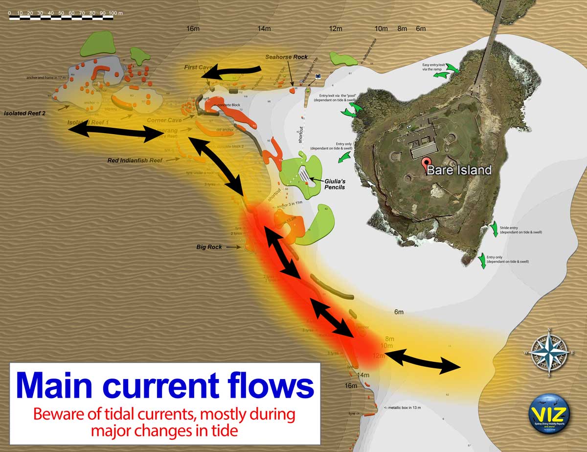 |
This shows the predominant tidal currents at Bare Island. Incoming are the currents to left, outgoing to right. Created by Marco Bordieri from www.viz.net.au using my information.
Used with permission of Marco Bordieri |
ACCESS FROM BARE ISLAND - Normally a longer swim (but see last option) and harder to find but may be easier for newer divers.
Option 1
Upon arriving at La Perouse, park at the normal location above the bridge and follow the directions in the Bare Island Right dive to Point B. On your first exploration here, do not take too much time to get to this point as the reef is deeper and you will use a bit of air exploring it.
Once at the first cave, drop deeper to the north. There is a sort of wall here but really it consists of a lot of small and largish boulders. Here you will see some wreckage from a fibreglass boat. This consists of part of a side and top of a hull and has a small stainless steel rail, although it is sometimes partially or totally buried in sand.
From this point (depth about 16 metres), head west for another 15 metres and then head due north for about 20 metres across a sandy patch (with some large rocks). If you come up a bit and then drop and turn to the south before turning to the right, then you have gone too far. The sand contains a lot of interesting fish, including some huge flathead, up to 1.25 metres in length (I saw 6 in one square metre in February 2002 and three in August 2003). You should by now have deepened to almost 17 or 18 metres and encountered some more rocks and then a substantial isolated reef. This is Isolated Reef One.
 |  |
| The artificial reef between the mainland and Isolated Reefs | A sea dragon seen August 2005 at this site |
You can also go to the second cave where the sea horses used to live. If you go south-west from here across about 15 metres of sand you will come to a small ledge at about 14 to 15 metres. Follow this to the right (roughly west) till it seemingly ends and then continue in the same direction for about 15 metres and it will drop to 16 to 17 metres and you will see some rocks. This takes you to Isolated Reef One. You will need to follow the reverse of the dive described below as you will be at the south-eastern corner of the reef.
Option 2
If you walk right out to the western most point of Bare Island, you can enter the water here (if it is very calm). Swim out about 10 metres and descend. Head due west. After two minutes you will drop on a slope that goes from five metres and after another minute be at about 9 to 10 metres. This is to the south-east of the second cave on Bare Island Right. If you keep heading west you will cross over a short section of sand and then come to the 14-15 metre ledge from Bare Island Deep Wall where the pygmy pipe horses are sometimes found.
 |  |
| A drone photograph of Bare Island from the north | A drone photo of the entry points 2 and 3
2 is the bottom right corner of rock platform, 3 is the pool which is fairly obvious |
If you follow this to the right (a little to north of west) to the end and then head north across a small section of sand, you will strike the start of Isolated Reef One at about the same location as the above two options. This will take about seven or eight minutes.
Option 3
Walk out to the western end of Bare Island but enter the water through the small "pool" (created by natural rocks). You would only use this as an alternative to Option 2 if the seas are too rough for that entry. Once in the water, swim out about 10 metres and descend. Head due west. After about three minutes you will cross a small sand gutter and work your way through the boulders ahead. A minute later you will come out on the main western wall (Right Side) and be just to the east of Sea Horse Rock. Follow the reef, keeping down near the furtherest rocks from the main reef. This is a bit deeper and you will use more air than Option 2. After a total of about seven minutes you will be to the north of the first cave and will need to follow the rocks to the north. After about eight or nine minutes you will come to Isolated Reef One.
ACCESS FROM MAINLAND - Shorter swim than Option One but longer than the rest, possible cross currents, only for experienced divers.
Option 4
Upon arriving at La Perouse, go past the normal location parking spot above the bridge and park in the right-angle parking carpark to the west of the normal parking spot. This overlooks the grassy flat area and the south-western point of La Perouse. Gear up here and walk across the grass and then down across the rock platform towards the point (you will see a large boating sign on the rocks). There is a nice entry and exit point here (in fact many) and just choose which one you want to use. Enter the water and go out about five metres before descending. Note that there can sometimes be strong currents on this dive. They appear to occur mostly when there is a very high tide or a very low tide. You should try to dive at high tide if possible (for clarity and less current), but you can still do safely at most times.
 | 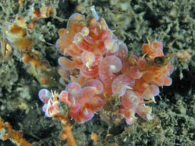 |
| A sea dragon seen 3 July 2011 on the south side of IR2 near the western end | A couple of made-up phyllodesmium nudibranchs - opera house nudis |
Once you have descended, the depth is about five metres. You should head due south. You will soon drop over a wall to the sand at 10 to 11 metres. Keep heading south. At about four minutes you should come across a series of concrete "alien pods". These were put here by NSW Fisheries as an artificial reef. These are quite small and very badly designed and constructed. They are much smaller than I had at first imagined them to be (only just over a metre high) and much thinner than I thought they would be. Of the 20 or so put here, at least one-third are broken, presumably by the action of the seas. In addition, they are about 30 or 40 metres to the east of where they are supposed to be according to the GPS co-ordinates on the Fisheries web site (hence it took me about 8 months to find). There is a bit of growth on them already but not much fish life. They are just too small to achieve anything. This was apparently a trial, and I was told by a Fisheries person that the new ones are bigger and more substantially made. I hope so. Even in 2012 there is not much more growth and there are only very small fish present.
Anyway, from here continue south till you hit the isolated reefs. It will take about seven minutes of constant swimming (excluding the stop) before you will see the reef. You should hit Isolated Reef One approximately where it meets the main Bare Island Right reef. The depth will be about 15 to 16 metres.
If you start about 20 metres to the east of the point, you may see the wreck of a small aluminium boat after about 3 minutes.
Depending on the current (if present), I would normally turn right and follow the reef edge. You will be on Isolated Reef One.
Option 5
Upon arriving at La Perouse, go past the normal location parking spot above the bridge and park in the right-angle parking carpark. This overlooks the grassy flat area and the south-western point of La Perouse. Gear up here and walk across the grass and then down across the rock platform towards the point (you will see a large boating sign on the rocks). There is a nice entry and exit point here (in fact many) and just choose which one you want to use. Enter the water and go out about five metres before descending. Note that there can sometimes be strong currents on this dive. They appear to occur mostly when there is a very high tide or a very low tide. You should try to dive at high tide if possible (for clarity and less current), but you can still do safely at most times.
Once you have descended, the depth is about five metres. You should head south-west. You will soon drop over a wall to the sand at 10 to 11 metres. Keep heading south-west till you hit the isolated reefs. If you start right at the end, you will see a small putt-putt boat as you go. It will take about 8 to 9 minutes of constant swimming before you will see the reef.
As of October 2012 you will pass over three cables. These are the new electricity cables that have been laid from La Perouse to Kurnell. They were supposed to be buried and the ends covered in a pile of small rocks. Energy Australia (or Ausgrid or whatever they are called this week) claimed that this would happen in mid-2011. However, in October 2012 the ends of the cables still were not buried. Bullshit artists is the only thing I can use to describe what they are! In 2022 they are still not buried.
Note that the electricity cables appear to affect the accuracy of compasses, as divers on dives here have reported that they have ended up well off the planned route. Take care.
You will get to almost 19 metres before coming back up a little just before the reef is found. You should hit Isolated Reef Two approximately half way along near the old anchor and rope and slate. The depth will be just over 18 metres.
Heading south-south-west will bring you to about the gap between Isolated Reef One and Isolated Reef Two. If you go for more than 10 minutes, turn left and head east and you should hit the reef.
ISOLATED REEF ONE
This reef is actually oval or almost rectangular in shape. From the Bare Island side it runs in a west or slightly west-north-west direction. The northern side is deeper being about 18 to 19 metres at high tide, although this is off the main reef behind the boulders that lie on the sand. Take particular notice of where you have hit the reef as when you come back to this point, you need to be aware of this spot so you do not end up going in circles (like I did on my first dive here). If you follow the northern side to the west or west-north-west (keeping the reef on your left), you will notice a wall with many indents and small cracks with some large rocks off the wall. The depth close to the main reef is about 16 to 17 metres whereas it is 18 to 19 metres near the rocks off to the north.
In poor visibility, it is possible to follow the deeper rocks straight onto Isolated Reef Two without even realising what you have done (and vica versa). The top of the reef is 11 to 12 metres and it is very interesting.
 | 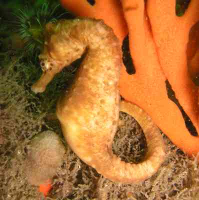 |
| A lower section of the Isolated Reef, northern side | A big belly sea horse similar to the ones seen at this site |
This reef consists of a decent wall (perhaps two metres high). If you follow this it will deepen from 17 metres to over 19 metres at high tide and then back to 18 metres. The reef is covered with great sponge life, sea squirts, small gorgonias and many other species of fixed marine life. There are some small overhangs and cracks. Many times we have found red indianfish along the rocks just off the wall in this area. Also lots of sea dragons used to be seen in this area, but since November 2009, I have only seen a total of seven on four dives, despite diving here at least 12 times. Also look for firefish and pygmy pipehorses. Check your air as you go. If you get short before you turn to the south, turn back.
The reef runs west-north-west for perhaps 60 to 70 metres (it is about 30 to 35 metres wide) and then turns south. In this area you will notice some rocks running off in the same direction as the reef you have been following. This leads to the start of Isolated Reef Two which is an off-shoot from Isolated Reef One that runs north-west from the north-western end of Isolated Reef One. Around this spot I saw (in August 2005) a Red Indianfish.
If you are doing this dive from Bare Island, it is unlikely that you will have sufficient air to be able to explore Isolated Reef Two unless you are a very experienced diver and good on your air. In poor visibility it may be difficult to actually notice where you change direction and it may appear that you are going straight (or alternatively, you may run off following the rocks over to Isolated Reef Two in error). Keep a good check on your compass as you go. Along the southern side we found a tiny sea dragon in January 2006.
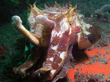 | 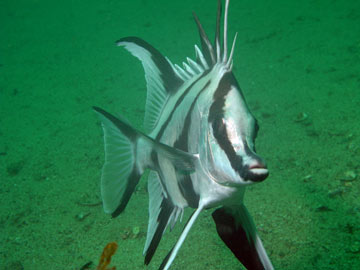 |
| A Cuttlefish at Isolated Reef | A boarfish seen between Isolated Reef One and the main reef |
Isolated Reef One has lots of old anchors and ropes lying everywhere and there are plenty of small inlets. I have explored these but there is still much to be seen. The southern side of the reef is a bit shallower at 16 to 17 metres. It has less fixed marine life in spots, but is still very good.
After about 20 minutes on this reef (slow moving) or 15 minutes moving a bit faster, you will be back at the point where you met it. Hopefully you have found something that stands out (like an anchor or rope) and refound it. To return to Bare Island via Bare Island Right, go south-east and you will encounter the start of the main reef after about 20 to 30 metres and the depth will be back at 14 to 16 metres, depending on where you hit it. Follow the directions in Bare Island Right dive to get back to the shore.
If you have started this dive from the mainland, you will normally have come across to Isolated Reef One from the mainland. Return back to the mainland by heading due north from this spot. At any time if you are lost or short of air, head north with a little east and you will be safe. This will meet the mainland to the east of where you entered the water.
On Isolated Reef One I regularly see red Indianfish (large orange and pink ones - up to three on a dive) and I used to see sea dragons (up to seven - none since 2012 or so), a couple of sea horses, kingfish, flathead and huge numbers of sweep, small trevally, yellowtail and one-spot pullers. All over there are lots of colourful sponges, sea squirts and some small gorgonias.
ISOLATED REEF TWO
Isolated Reef Two is a deeper reef overall than Isolated Reef One. In fact, I think that it is probably the more interesting of the two reefs. It does not matter where you start this dive (island or mainland), if you have followed the information in this article you will hit this reef in almost the same spot, that is, the south-eastern end (this is from the north-eastern end of Isolated Reef One) unless you have come from the mainland and headed south-west. Follow it on the northern side, keeping the reef on your left (you will be roughly heading west).
On 20 January 2008 we found a big belly sea horse on a rock right at the closest point to IR1. This was a bright yellow colour with black spots, on its left side it had five spots in a square shape with one in the middle and below this four spots in a square shape. All along this reef there are plenty of anchors, with rope and chain all over the place as well as lots of pieces of wrecked boats. The depth is mostly 19 metres on the sand (at high tide), with the top of the reef coming up to 15 metres or even a bit shallower in spots. The "inland" has some very interesting bits to see. There are lots of cracks, holes and spots to explore. There are also a lot of fish up here, seapike, sweep, yellowtail and more.
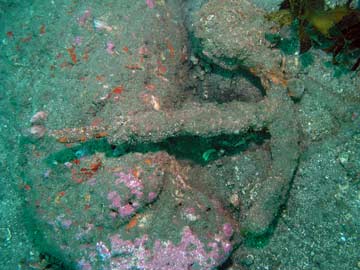 |  |
| A small but old Admiralty anchor on Isolated Reef Two | A metal ring of some sort on Isolated Reef Two |
As you follow this edge, there are small walls and some inlets. Off the reef there are lots of low rocks. Some are small and some are large. These rocks, as well as the reef, are covered in fantastic sponge life. There are quite a few sea horses to see (all big belly as far as I can see) and numerous sea dragons. On one dive here in December 2004, I saw 9 sea dragons on this reef, three of which were males carrying eggs. In fact, one of them was tagged with a minute colour tag showing that it had been tagged in 2000 at Inscription Point on the other side of Botany Bay. This study is being carried out by Jaime Sanchez Camara from Spain. This is a first, showing that sea dragons may move long distances. It was previously thought that their movement was limited to about 100 metres (no others have been seen outside the originally tagging location). This is a first, showing that sea dragons may move long distances. For more information about sea dragons, see my Sea Dragon Page.
This reef is shaped more like a circle (rather than a "breaking wave" as shown in the Sydney Viz map). It is also a bit bigger than Reef One, probably 70 to 80 metres east to west and 50 metres north to south. The northern side runs west or north-north-west and then south-west and south before turning to east or south-south-east on the southern side. Along the northern side there are some interesting objects to see that will help you navigate.
One is a long section of rope that runs from the sand over the reef and onto the top. This was attached to a white slate that I thought was from an old research experiment but I now know was put there by some divers who dived here from a boat thinking they were the first and only ones to dive this spot. In early 2007 they replaced the slate with a new one, asking people to write a message if you see it. In April 2007 I put a "No Swimming - Sharks" sign here as a result of the furour that went on when an alleged great white shark was sighted near here in January 2007.
About five metres past here there are some iron or steel objects, one of which appears to be a very old (say 100 years or more) Admiralty shaped anchor. It is very small, perhaps from a very small skiff or rowing boat and a ring of some sort (see the photographs above). About 25 metres further along you will start to reach the end of the reef.
 |  |
| A red Indianfish at Bare Island | A couple of sea dragons on the southern side of Reef Two |
You will notice on your compass that you are turning to the south. In late October 2012 I did a night dive here and noticed that there were many changes. A huge rock (at least the size of a kitchen) appears to have moved from the top of the reef to a spot off the main reef. There was a lot of broken rock (white in colour). Further around, there was at least one more huge rock moved and more broken rocks. It seems that the huge seas in late September and October 2012 have moved rocks. This was confirmed by later day dives when the original location of the boulders was easily seen.
On the south-western corner of this reef there is another huge boulder that sort of sits off the reef. You can either go around this or cut between the rock and reef. Now you will be heading back in a south-eastern direction. The depth is a bit shallower, perhaps 17 to 18 metres. It is similar to the other side, with lots of small gullies and inlets and heaps of sponge life. The gullies have lots of fish in them, one-spot pullers, ladder-finned pomfrets, yellowtail and small seapike. There are also at times lots of large luderick. Keep an eye out for sea horses and sea dragons. We have seen large schools of old wives on the sand at the end and medium sized schools of large kingfish here as well. At times there are huge schools of fish here, with all the above fish seen as well as lots of trevally.
There were more changes in late 2024 when storms moved a lot of smaller boulders/rocks off the main reef onto the sand. Accordingly, the reef here no longer has a very distinct wall like it used to.
As you head east on the southern side, you will see that there are some large "bays" along this side, including two right near the western end. The reef heads out a bit to the south and is low past these bays. The main wall is a bit to the north across the lower reef. There are normally many sea dragons here. This part of the reef heads north-east.
When the reef starts to turn to the north, this is the end of Isolated Reef Two. In late 2024 this had also changed, with a lot more sand up against what used to be a small wall. Now it is only like a step up from the sand to the reef. When you are heading north, Isolated Reef One is located to the south-east, about 10 metres across the sand and rocks. If you have come from the island and intend to return that way, go across to Isolated Reef One and follow the southern side as per Isolated Reef One above. If you have come from the mainland and are short of air, you can head north-east from this location if you want or go back from the other end of Isolated Reef One. After about seven to eight minutes you will reach the mainland and I would suggest doing some safety stop as you have been at 18 to 20 metres for most of the dive. Exit back onto the same rock where you entered.
ISOLATED REEF THREE
NOTE: I thought at one time that there was a third reef but on rediving here a number of times in January 2006 in good visibility and in February 2006 with my scooter I can state that it does not exist. Perhaps there were some rocks that I previously saw that are now covered with sand.
SUMMARY
This is a great dive site. Visibility is varied, it can be as good as 20 metres but can be as bad as 2 metres. You should be able to spend 30 to 35 minutes on the reef, meaning a dive of about 45 to 60 minutes, depending on where you start and finish the dive.
Note that you can also start at the mainland and end up on Bare Island or start on the island and end up on the mainland. However, do not do this until you are experienced as a diver and experienced at this site. My preference is to use Option 2 for a starting point, do both reefs and then head back to the small boat ramp near the bridge. This takes me about 55 minutes going easy and as little as 43 minutes if I do not linger too long in one spot. I can easily do on a small 8 litre tank, although for most I would suggest 11 to 12 litre tanks are required.
Be wary of currents, as on large tide differences you can get quite strong currents, especially on the southern side of both reefs and between the reefs and the mainland. Visibility here is normally much better than the rest of Bare Island. Even at low tide when the viz has been as low as three or four metres elsewhere, we have had more than 25 metres here.
A fantastic dive, worth doing time and time again.
| 
 v6.00.307 © 2003-2005