|
Michael McFadyen's Scuba Diving - Ghavutu
The Honiara area of the Solomon Islands has some very good diving, both on Guadalcanal itself and the nearby island groups. Across Iron Bottom Sound from Guadalcanal are the Florida Islands. First "discovered" by the Spaniard Mendana in 1568, they are more correctly known as the Nggela Islands. The group is made up of Nggela Sule, Nggela Pile, Buena Vista Island, Sandfly Island (wouldn't you love to visit there!) plus 50 smaller islands.
Before World War II, the capital of the Solomon Islands was Tulagi (then more commonly spelt Tulaghi). This is a small island but ideally located with a protected harbour. One of the smaller islands in the Floridas is Ghavutu Island, about four kilometres east of Tulagi. Ghavutu is about 500 metres long and 250 metres wide. Before the war, Ghavutu was the base of Lever Brothers. They operated extensive coconut plantations in the Tulagi/Guadalcanal area. They had substantial infrastructure on the island, including docks and buildings.
 | 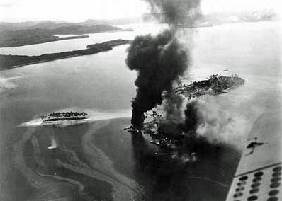 |
An aerial photograph of Ghavutu Island in 1940.
The wharf is located top right of island.
Tanambogo Island is top left. | An aerial photograph of Tanambogo Island under attack.
Ghavutu Island is located right, above smaller smoke plume |
On 3 May 1942 Japanese troops took Tulagi and seized control of all the adjacent areas. On the north-eastern corner of the island there was a substantial concrete wharf constructed by Lever Brothers or the Japanese (it is not clear who built it but it was there in early August 1942). As well, there were seaplane slips located to the east of the wharf (past the small inlet if you are standing on the wharf looking east). There are bits still visible today. It is reported that Ghavutu was also a Japanese submarine base as torpedoes were found on the western end of the island near the causeway (see next paragraph).
Ghavutu was connected to the west to Tanambogo Island by a 300 metre small concrete causeway. Tanambogo Island is even smaller than Ghavutu, onlu 300 metres by 75 metres or so. North of the two islands is another even smaller island. In between the smallest island and the other two islands, Japanese seaplanes were moored. When the US invaded on 7 August 1942, there were 13 sea planes based at Ghavutu Island. See my page on the Kawanishi Mavis for more details.
Soon after invading the Tulagi area, the Japanese commander began building an airfield on Guadalcanal. This was planned to be finished on 15 August 1942. This would enable Japan to have large bombers within range of Australia and other countries like New Caledonia and New Hebrides (now Vanuatu). As a result, the US decided to invade the Solomons, hopefully before the airfield was completed.
On 7 August 1942, the first day of the invasion (the Battle of Guadalcanal), Ghavutu was to be invaded in conjunction with the invasion of nearby Tulagi and Guadalcanal itself. At 1145 on that day, Douglas Dauntless SBD dive bombers attacked Ghavutu for 10 minutes and then the Tulagi Fire Support Group (a cruiser and two destroyers but I am not sure what the ships were) bombarded the island for five minutes while the 1st Parachute Battalion (acting as infantry) approached the island in Higgins landing craft. At 1200, the parachutists landed on the island in the area of the slips. The first wave reached shore but the next groups were hit hard by the Japanese. It is reported that one in ten were hit. Within two hours the Americans were approaching the island's lone hill, still under heavy fire. The Japanese were entrenched on the island in caves and bunkers (you can see some of these today as you walk up the track to the top of the hill). They were also firing from Tanambogo Island. For more infomation on this, see One Man's View by Leonard E. Skinner. Len was a Marine who landed on the island in the first wave and his on-line story makes very interesting reading. See references. He also confirms that Ghavutu was a Japanese submarine base.
By 1800 the Americans had captured the hill (the Japanese flag from here is now at the Marine Corps Base in San Diego). By the next day, the island was totally in American hands, with the 1st Parachute Battalion now supported by two companies of the 2nd Marines. It is reported that the parachutists and marines suffered when they were shelled and bombed by their own forces. As mentioned above, Ghavutu Island was connected to the adjacent island Tanambogo by a causeway and the fight for that island was carried out at the same time. On 7 August 1942 B Company of the 2nd Marines attempted to invade the island after a short aerial and water based bombardment but this failed. At 1130 on 8 August 1942, the 3rd Battalion of the 2nd Marines and two light tanks attacked Tanambogo from the beach and causeway. At 1620 the Third Battalion of the Second Regiment of the Marines stormed across the causeway, bayonets fixed. By late afternoon most of the island had been captured. It is reported that by dusk all the Japanese on the island were dead. Len Skinner claimed the Japanese flag from Tanambogo Island.
During the attacks on the two islands, 108 marines were killed or missing and 140 injured, quite a heavy toll when the size of the islands is considered. Marines estimated that they had fought 1000 Japanese but the real figure was about 500. Len Skinner says that 50 marines were buried on Ghavutu and about 1000 Japanese interred in the caves they were hiding in. I do not think this is accurate or even correct.
Len Skinner wrote in his story that about seventy or eighty feet offshore, directly in front of his foxhole, rested a huge Kawanishi seaplane that was sunk by US aircraft on 7 August 1942. He reported that it was in quite shallow water and most of the plane was above water. On the first night in his foxhole a Japanese soldier had gone out to the plane and turned its machine guns on him. He replied with return fire and the following day they removed the guns so such an incident could not happen again. Len removed the two aluminum specification plates from the plane for a souvenir and also cut a section out of the red rising sun painted on the fabric-covered wings. He still has these. See later for more about this.
During the attack, the Japanese flying boat tender Akitsushima was seen in the area on its way to Gizo where it was going to establish a sea plane base. Just over a year later on 17 February 1944 the Akitsushima was in Chuuk Lagoon and damaged during the first raids by the American aircraft. It escaped through the South Pass and lived for another day. It was also in Palau just prior to the attacks by the Americans on 30 and 31 March 1944. The Akitsushima was finally sunk by the Americans on 24 September 1944 at Coron in the Philippines.
On Saturday 5 December 1942 VCS Detachment RINGBOLT was established at Tanambogo. This was composed of Curtis SOC-1 and SOC-2 "Seagull" Scout seaplanes from the heavy cruisers USS Pensacola (CA-24), USS Northampton (CA-26), USS New Orleans (CA-32), USS Minneapolis (CA-36) and the light cruiser USS Honolulu (CL-48). Operations of the new unit commenced immediately. Two Seagulls patrolled on this night with patrol boats. A lack of equipment and communication difficulties handicaped operations that were carried out on moonless nights in rain squalls. The only facility provided was a flashlight on the beach to guide the returning planes through reef passages after they landed. (Note: I think SOC stood for Scout Observation Craft; Not sure what VCS stood for but it was related to heavy cruisers - they carried four Seagulls).
The Seagulls contiuned operations till at least 4 February 1943.
The Americans used Ghavutu as a patrol boat base. There was also an observation post on the top of the island, togther with a large gun, some concrete water tanks (built by US SeaBee's unit CB26 on 9 April 1943 - you can see their inscriptions in the concrete today) and a flagpole. The men who worked there lived on Tanambogo and went across to Ghavutu each time they were on duty. Apparently the Americans still believed that there were Japanese on Ghavutu even months after they had taken the island. This was probably not true, the island is not that big, but they reported that it made them jittery when they were on night shifts.
During the War, the Royal New Zealand Air Force (RNZAF) had a squadron of Consolidated Vultee Model 28 PBY Catalina flying boats based in the Solomon Islands. I am not sure where they were based, but it is possible that the RNZAF were based at some time at Ghavutu, utilising the Japanese seaplane slips. I base this guess on the fact that I found some 1939 NZ beer bottles under the wharf. It is also possible (probable) that the US based Catalinas here as well and it is also reported that some Australian Catalinas may have been here as well.
In the newsletter of the Guadalcanal Campaign Veterans (dated September or October 2002) there was a letter from an Australian commando whose company was stationed on Tanambogo to provide protection for two squadrons of Catalina flying boats that were based there from January 1942 until they were forced to evacuate later in the year. He said they were bombed daily by Japanese planes, but they never hit a Catalina.
Philip Boothe was stationed on Tanambogo from June 1943 till June 1944 where he ran a fuel dump. He lived on Tanambogo but went across the causeway to Ghavutu for meals. There mostly refuelled small boats but on occasions, they refuelled Catalinas.
In 1992 and 2001 I visited Ghavutu Island. On both trips I did two dives in this area. The diving here represents both phases of the occupation of the islands. One of these dives was on Japanese "Mavis" flying boats. See the Mavis page for details of both planes I have dived here.
 |  |
| John Fowden swims under the Ghavatu Wharf in 1992 | John Fowden with a section of fighter plane fuselage - 1992 |
The other dives here were in the area of the main wharf. This site is normally done as a second dive as it is quite shallow. Both times I dived here we enjoyed a leisurely lunch on the wharf after a first dive elsewhere and then explored the island and saw the remains of buildings, fuel tanks, water tanks and underground bomb shelters. The island certainly looks different now to aerial photos I have seen in various war books. On my October 2001 trip here we also had lunch on the wharf. Parts of the island were cleared of vegetation prior to 2001 exposing war relics like more water tanks, flag poles and gun mounts that were not visible in 1992.
When you dive here the main dive site is under and in front of the wharf itself. Just like a mini Million Dollar Point, the seabed is covered with discarded war relics. Things to see include at least six aircraft wings, truck and plane engines, aircraft landing gear (how did they get here!) and sections of fuselage, all stripped of useable parts. A pontoon, what looks like a gun carriage and other larger objects can be found as well as gas masks and smaller pieces. There are also lots of Coke bottles (1944 mostly) and even a 1939 NZ beer bottle (Auckland Bottle Company).
 | 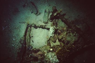 |
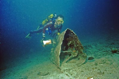
| A section of an aircraft wing near the Ghavatu Wharf - 1992 | An aircraft undercarriage - 1992 |
To the north-west of the wharf there are the large rusting remains of something like a huge pontoon. I do not know what it was, but you can see it from the wharf. Anyway, just deeper from here in 8 metres there are the remains of a plane. In 1992 when I dived here I did not see this but a number of other divers on the trip saw it. They reported to me that there were the remains of an American Consolidated Vultee PBY "Catalina" flying boat. From my conversations with them at the time, it appeared that it was an almost intact aircraft.
In July 2002, Ewan Stevenson of Auckland, emailed me with the information that his father (Charles C. "Jock" Stevenson), had told him on 14 July 2002 after he had shown him video and some drawings of the wreck now. This was as follows:
"[In mid-1964] We snorkelled the PBY wreckage [Dad still called it a "PBY" last night] near Gavutu Wharf....it was fairly shallow...about 25 feet to the sand. The plane was far more intact...there was fuselage and cockpit. We used to dive under the wings and into the cockpit area to see the instrument panel. The cockpit was open and smashed. The wing float was upright so the wing was upside down...that plane was complete..!" [Dad was very surprised at its deterioated smashed state today in the video]. Dad was very sure someone had attempted to lift the plane in more recent times (like 1970s)."..I think it was Dick Harper or Reg Thomas...they broke it into bits..."
Dad didn't recall the barge sitting near the plane wreckage. Dad had thought it was always a PBY....I showed Dad the book "PBY in Detail & Scale". "You're right, Ewan" Dad said... "the float on the wreckage didn't have that broad piece underneath [like a PBY wingfloat] it was all open but I don't recall the bracing wires, but they must have been there..." "also the engines weren't that close together [looking at the PBY picture]". ie. supporting evidence the wreckage is H6K.
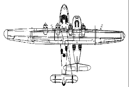 |
Diagram of a Catalina overlaid on a Mavis. The Mavis fueslage
is in middle. Note that the wings almost identically match from starboard tips to Mavis inner port engine.
Note scale is approximately the same. |
Charles Stevenson's memories are very much like the information passed onto me by my friends in 1992. That is, that the plane was fairly intact.
The fact of there being a plane at this location was disputed to me by a well known Australian tech diver in an email to me in June 2001 (not many years ago as he stated in DIVE Log in July 2002). In October 2001 I found what I assume is the plane referred to in 1992 and referred to by Charles Stevenson. However, it is certainly not intact now, consisting of the wing section from one tip past one engine to the next engine (it appeared to me to be upside down - matching Charles Stevenson's memories of 1964). The second engine is not in place nor is the rest of the wing. It is hard to tell if this is all of one wing and part of the other (ie a 2 engined plane) or virtually all of one wing (ie a 4 engined plane). See the diagram at left and you notice how hard it is to tell the difference.
Under the wing is what appears to be the fuselage, or at least part of the fuselage. It is very hard to tell as this is buried in sand as well as being under the wing section.
Ewan Stevenson, who is very knowledgeable on shipwrecks, especially in the Solomons, had emailed me in June 2002 about a number of matters. One of the things we discussed was this aircraft. He has told me that he had videoed and measured the wing and came to the conclusion that it is a Mavis. I intended to try to revisit the Solomons again in 2006 when I would take my own measurements and video. However, due to another uprising we cancelled the trip. I am visiting in 2009 so will do it them.
I had intended to video this section of plane in 2001 and later compare this to plans and photos of Catalina and Mavis aircraft. However, my video battery failed before I could do this. Anyway, while it is still possible that it is a Catalina, based on the information from Len Skinner and Ewan and Charles Stevenson, it is more likely that it is a Mavis wing section. Both planes had similar wings that were straight and not tapered.
Right next to the wing, a little deeper, there is a small landing craft, with the front door open. Much deeper, in 30 metres, there are two more landing craft, one of which we (we think) discovered in 2001. One is probably the same size as this one and the other much bigger, with two guns on it. There are probably more in this area as well.
Another thing to look for under the edge of the wharf itself are prawn killers (or mantis shrimps). These strange looking animals are among the most voracious animals in the sea and can be seen in a number of places, including the southern end of the wharf. The depth of water on this dive ranges from 6 to 15 metres (unless you go to the other landing craft), with 12 being an average. Visibility is 10 to 12 metres.
All in all, a very nice place for a shallow dive after the deeper ones.
I dived in 2001 with Solomon Sea Sports. This operation changed ownership in early 2002 and is now Dive Tulagi. They have move location to Tulagi in 2002. See my Tulagi page for more information. I tried to dive here again in September 2009 but it appears that the dolphin operation that is running in the Solomons (capturing, training and exporting dolphins - brilliant idea, take dolphins from the wild, cage them and watch them die) has taken over this island and the waters nearby. It also seems that for some unknown reason, they removed some of the aircraft pieces from the water. It is possible that you can now not dive here.
Dives:
11 August 1992
26 October 2001
NOTE: Underwater photographs taken with Niklonos IV-A in 1992 and scanned 2011.
References:
The Shame of Savo by Bruce Loxton with Chris Coulthard-Clark
US Fleet Carriers of World War II by Richard Humble pages 115-9
US Navy at War 1941-45 by Fleet Admiral Ernest J. King page 117
Hailstorm over Truk Lagoon by Klaus Lindemann various pages and photo opposite page 96
Desecrate 1 by Klaus Lindemann pages 149 and 264
.....the memoirs of William T. Paull by William T. Paull, USMC
Jane's Fighting Aircraft of World War II
The Lost Ships of Guadalcanal by Robert D. Ballard, pages 30 and 39
The United States Army in World War II - The War in the Pacific - Guadalcanal: The First Offensiveby John Miller, Jr, various pages
Jane's Fighting Aircraft of World War II page 41
Various e-mails from Ewan Stevenson of Auckland, New Zealand
One Man's View by Leonard E. Skinner -
An e-mail from Philip Boothe dated 19 February 2003
|  v6.00.307 © 2003-2005

