|
Friday 10 April 2009
Back in September 2006, Kelly and I did a trip through Western NSW. Towards the end of the trip, we ended up at Temora where we visited the Temora Aviation Museum. We so enjoyed this, we vowed to go back for an air show as well as stay at Weddin Mountains and Nangar National Parks.
On this trip we have Ron and Donna in a Toyota Prado with camper trailer and Robyn and Chicka in an 80 Series Toyota LandCruiser. They left Sydney the day before us and we will meet up with them later today.
Kelly and I left Kirrawee just after 7 am. We travel via the M5, M7 and M4 to the Lower Blue Mountains and then via the Great Western Highway to Bathurst. We arrive at Bathurst at 9:30 am and here we stop for morning tea in a very nice park alongside the Macquarie River. This is as you come into Bathurst and is on the right side.
We are back on the road again at 9:45 am. We drive through Bathurst and then take the Cowra Road. Our plan is to stop at Cowra and have a look at the site of the former World War II Japanese prisoner of war camp as well as the memorials to the Japanese and Australians killed when the Japanese staged a mass break out.
The breakout happened at 2 am on 5 August 1944 when at least 545 prisoners attempted to escape. It appears they did this as they were informed the say before that they were to be moved to another camp at Hay.
Two Australia guards used a machine-gun to try to halt the flow of Japanese as they stormed the wire fence surrounding the camp. They were eventually over-whelmed and killed. A total of 231 Japanese and 4 Australians were killed in the outbreak and subsequent search for the escapees. There were also 108 Japanese wounded. Some of the prisoners who died committed suicide (either as an alternative to been involved in the escape or prior to recapture) and other were reportedly killed by their own countrymen because they refused to attempt to escape.
A total of 359 POWs escaped. All the escapees were recaptured within 10 days. Today there is a Japanese war cemetery as well as a Japanese memorial garden at Cowra.
We arrive in Cowra at 11 am and go to the Japanese Gardens first. This is the only one of the four things we want to see that is signposted and also with information on the internet. The road to the gardens comes off the main street (to the right) in the middle of the town. The gardens were opened in 1989 and are built on a small hillside. Unfortunately, the on and off rain that we have had since Bathurst now settles into constant rain.
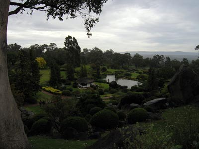 | 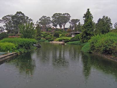 |
| Cowra Japanese Gardens | Cowra Japanese Gardens |
The entry fee is $9.50 per person and we spend about 30 minutes looking at the gardens and the small Japanese cultural museum. There is even a replica of a Japanese house to inspect. It is a pity that they rain came, as I would have liked to spend more time here.
From here there are signs to the prisoner of war camp. This is on the same road as the gardens and only just over a kilometre away. It is still raining so we can only have a quick look. There is a replica of a guard tower and some interpretative signs. The camp is still there, at least the footings from most of the buildings. You can look at the photos from the day of the escape and make out which ruins was which building.
 |  |
| The replica guard tower at the POW Camp site | Looking past the interpretation signs towards
the Cowra POW Camp. The camp was over the fence |
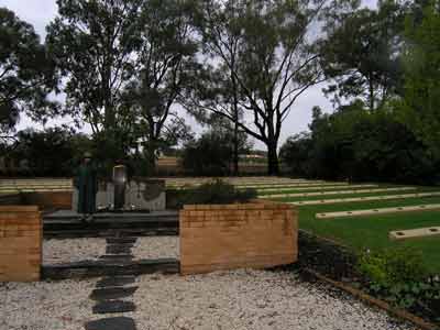
From here there are signs to the cemeteries. This is on the other road that intersects with the road you have come in on. Again, it is only about a kilometre to drive.
The rain stops as we arrive. The war cemeteries are adjacent to the general cemetery. At the front is the Australian War Cemetery. This has the bodies of 27 soldiers, including the four soldiers killed during the breakout. The others are men who died while based in the Cowra area. These were killed in accidents or who died from other means.
The Japanese War Cemetery is said to be the only one in the world. In it are all the men killed in the breakout as well as prisoners who died from natural causes (some were 70 and 76 years old). There 522 bodies all up, including 31 Japanese airmen killed when shot down over Darwin and one unidentified soldier. It is a very sad thing to see so many Japanese and Australians dead in this beautiful place.
 | 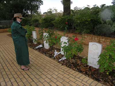 |
| This is the Cowra Japanese War Cemetery | Kelly looking at the graves in the
Cowra Australian War Cemetery |
These cemeteries are looked after by the Office of Australian War Graves (http://www.dva.gov.au/oawg/).
Apparently the general cemetery has the bodies of Italians and Indonesians.
After looking at the cemeteries and garden, we head back towards the main street (the Mid Western Highway) and cross over the Lachlan River. On the left is a very nice park and there are a few undercover tables. It is lightly sprinkling so the protection is nice. We have lunch here.
We are back on the road by 1 pm. We head to Grenfell and then onto Weddin Mountains National Park. While only one camping area is shown on the national parks' web site, there are apparently two, one of which, Holy Camp Camping Area, Robyn and Chick were going to stay at last night. However, it appears that this camp site is no longer open for unknown reasons. We are going to the other one, Ben Hall Camping Area, which is the one mentioned on the national parks' web site. This is closer to Temora.
Everything is closed in Grenfell as we pass through (same as Cowra) as it is Good Friday. The access to the camping area is well signposted about five kilometres the other side of Grenfell. We take this road and along the sides of the tarred road we stop and cut some firewood from fallen trees along side. We need a fair bit, as we are having a big roast cook up tonight.
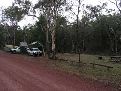
We arrive at 3 pm to find that the others have saved us a spot. As I mentioned in my article on our western NSW trip in 2006, this is one of the best set up camping areas I have been in. However, it is fairly full as the Canberra Ornithologists Group is there on a bird watching weekend. We still have a good site and there are no people really close to us.
 |  |
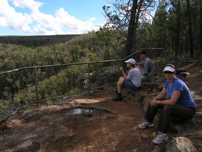
| Our site at the Ben Hall Camping Area | The view from the Ben Hall Cave |
Kelly and I soon set up our gear and as does Robyn and Chicka. They and Ron and Donna have only just returned from a walk that went from Holy Camp to a lookout. We all decide to go for the short walk to Ben Halls Cave. This is where the bushranger Ben Hall is said to have watched as stage coaches headed from Griffith to Grenfell and then set off on his attempts to rob them.
After this we relax and have a few drinks. I get the fire going as we are having a big roast dinner. We are cooking pork, Ron beef and Robyn chicken. We get a roaring fire going and by 6:30 pm we have lots of hot coals. We put the camp ovens on and they take about an hour to cook. Meanwhile, Ron makes a very nice damper that we have as an entree.
All the meats and vegies are excellent, and we have a very nice dinner indeed. A few more drinks and we head off to bed.
Saturday 11 April 2009
We are up early as we want to be at Temora about 10 am. It is approximately 75 minutes drive, although the various GPS units want to take us different ways.
We leave at 8:45 am and get to Temora at 10:00 am. It is an easy drive along dirt and tarred roads. Before heading to the airport, we go into town to get a few things that we need for meals today and tomorrow. After this we head out to the airport. There is a bit of a queue as we near as this is the first flying day this year (the previous one was cancelled due to the death of one of the founders, Tom Moon, in January). It is $15 to enter and there are probably 2,000 or so people here.
 |  |
| Douglas C-47 Dakota | Supermarine Spitfire Mark XVI and CAC Boomerang |
Despite this, it is not too crowded. We have taken chairs with us so we grab a spot on a grassed section. The first planes start up and four head off in formation. It is well before the advertised starting time and the Spitfire, Wirraway, Boomerang and Harvard are already flying.
At 11 am a memorial service to Tom Moon is held and at the conclusion, the four aircraft come in low over the airport in a missing man formation and the Boomerang does the classic peal off representing the lost pilot.
During the rest of the day there are lots of different aircraft flown. Our favourite ones were the Boomerang (an Australian designed and built fighter), the Spitfire Mark XVI and the Cessna Dragonfly. The Vampire and Meteor jet fighters were also great. The Spitfire sounds so good, its V12 Rolls Royce Merlin engine's purr is so unique. It is also so fast and graceful. The Boomerang has a great whistling sound and it sounds deadly (even though it was not really).
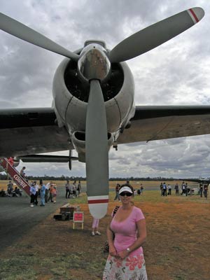 | 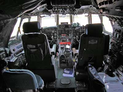 |
| Kelly with the enormous prop of the Lockheed Constellation | Inside the Constellation's cockpit |
The Dragonfly is a twin-engined jet that served during the Vietnam War. It is flown today by David Lowy, the founder of the museum. He is having a great time, doing aerobatics and making some spectacular turns.
As well as these planes, the Douglas C-47 Dakota (DC-3) and huge Lockhead Constellation are also popular with us and the crowd. There is a short break for lunch and Kelly, Ron, Donna and I pay $5 to go on the Constellation for a look-see.
It is a bit crowded at the food stalls for lunch, but the food is good and cheaply priced ($3 for sausage sandwich, $4.50 for steak sandwich).
The flying finishes at 3 pm. After this all the planes are lined up on the tarmac and you can walk right up to them for closer photographs. The pilots are also available for the visitors to ask questions. An approaching storm means that this is cut short (there is a lot of lightning).
 | 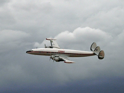 |
| Lockheed A-29 Hudson and Lockheed 12 | The Lockheed Super Constellation |
We head back to the cars and it is starting to rain. Once in the cars it is raining more heavily. There is a bit of a traffic jam to get out, but not too bad as many people have already left. As we head through Temora we see that it must have poured in the southern part of the town as there is a huge river of water flowing down the stormwater canals.
It rains nearly all the way back to Weddin Mountains National Park. We stop and cut some wood for the fire and barbecue as we near the camping area.
Kelly and I cook some great T-bones and sausages for dinner. Afterwards, I cook my apple crusty pudding in the camp oven and we all have this as dessert.
Sunday 12 April 2009
Today we are moving camp. The original plan was to go to Nangar National Park but we have a new plan. This is to go to Conimbla National Park and if the Camping Area there is okay (and empty) we plan to stay here.
We leave about 9:30 am and stop along the way to collect some more firewood. In Grenfell we have morning tea at the only cafe that is open.
The brochures and national parks' web site for Conimbla National Park do not indicate how to get to the park from the west (we do not want to go all the way to Cowra and then come back that way). The brochure shows a road that we can access but it does not give it a name. Our GPS shows that we need to turn at one road (with a different name to that shown on the sign-post) but we do not think this is right. We head to the road a few kilometres along that we noticed on Friday that has the same name as the road in the park (Kangarooby Road). However, once we get on this road there is a sign saying it is a no through road.
We head back to Major West Road (is this named by a Lost in Space fan?) and take this as the GPS tried to get us to do in the first place. This heads north and we soon realise that this is the correct road as the track matches that on the brochure. It is a pretty good dirt road.
This brings us to the main road that passes through the national park (it is Kangarooby Road and Barryrenie Road depending where you look). We turn back along the Barryrenie Road section towards Cowra and only just over a kilometre along we come to Wallaby Picnic Area. The national parks' web site does not show it, but this is a camping area. The park brochure does as does the signposting. This is a small site found on the side of the road. It has space for about six to eight cars. There are two fireplaces and tables and a pit toilet.
 |  |
| Wallaby Camping Area in Conimbla National Park | The view from the lookout at the end of the Ironbark Walking Track |
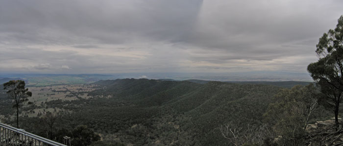
We decide to stay here the night and set up camp. We have lunch and then Ron, Donna, Kelly and I head off for a walk. There are two walking tracks in the park. The first is the Wallaby Walking Track which goes from here to the Ironbark Picnic Area. It is a two kilometre walk (according to the sign) and it takes 30 minutes to do one-way (compared to the 60 minutes the sign says). From here there is another walk called the Ironbark Walking Track. This heads out to the edge of the park and there are some views to the east. It ends up at a lookout that has views of a creek and a shear rock face.
We see some interesting things on this walk, a few wallabies and kangaroos, some lizards and a few birds. Kelly finds a trapdoor spider, seeing it quickly shut its door as she approaches. We later find some more open ones, with very well camouflaged doors that we would have never noticed if they were closed.
From the lookout we head back to the fire trail that comes from the south to the Ironbark Picnic Area. I believe that this is a continuation of Kangarooby Road that we attempted to drive up earlier today. We walk back along the trail and return to the picnic area. It has taken us 90 minutes compared to the two hours the sign says. We walk back to the Wallaby Picnic Area along the main road.
The two walks took us a total of two hours and 15 minutes.
We spend the rest of the day reading and resting.
A few of us have hot showers and then we get the fire going. Kelly and I are cooking pizzas tonight so we need some hot coals. We end up cooking some bread and then three small pizzas that take about 10 minutes each to cook.
A few more drinks and we are off to bed. It rains a bit during the night.
Monday 13 April 2009
Today Kelly and I are heading home, while Ron and Donna are staying here another night. Robyn and Chicka are coming with us but will probably stop in Nangar National Park and camp there the night.
We head off at 9:30 am and travel via Gooloogong (a great log hall opposite the pub which also looks nice) and Eugowra. The turn off to Nangar National Park is about 10 kilometres along the Orange Road (Escort Way). When we visited here back in September 2006 the access road was not signposted and the directions on the national parks' web site was contradictory. It is still not correct and is contradictory, as the distance from Eugowra to the turn-off is 10 kilometres not 15 kilometres as stated on the web site (another spot does say it is 10 kilometres). However, the brochure for the park appears to be correct. The access road is just past the O-70 sign (Orange 70 kilometres) and past the Nangar property access. From Orange look for the sign about 70 kilometres after leaving the centre of Orange.
We arrive at the Terarra Creek Camping Area to find about five vehicles here. Despite what is stated on the web site that there are only six sites here, there is space for at least 15 vehicles to camp in comfort. Robyn and Chicka have a quick look and decide to accompany us to Mount Nangar.
 |
| The view to the north-east from the Mount Nanagar Lookout |
We go to the Dripping Hole (which is not dripping despite the rain) and then across the park and up the track to the lookout. This is 4WD only, with lots of first gear high range. We arrive here at 11:30 am. There are some walkers who have taken one hour to come from the Dripping Hole (about three kilometres). The views are not as good as last time as there is a lot of low cloud and mist and rain around.
We have a cuppa and then Kelly and I bade farewell to Robyn and Chicka. We go back down the hill and take the track to the east. This is not mentioned as an access on the web site or brochure but is shown on the brochure's map. It comes out onto private property and after a few gates, ends up on the Canowindra to Longs Corner Road (this is on the Escort Way). There is some mention of this on the web site but it says there is no vehicular access to the park from either way and that you have to walk from the boundary.
Anyway, we head back to Escort Way and then travel to Orange. We stop past Orange at Macquarie Woods, a great state forest camping area that Robyn told us about. We have lunch here.
From here we travel back to Sydney, striking horrendous traffic before Mount Victoria that stretches to Blackheath (six kilometres). It takes us at least an hour to travel this distance. Further along at Leura we strike as bad conditions. It takes us at least 40 minutes to travel the short distance from Leura to Wentworth Falls. I consult the street directory and find that if we turn off at Wentworth Falls we can run parallel to the highway till Lawson. We do this and save at least an hour I reckon. From here we have a clear run (we have to stop for fuel as the traffic jams have used a lot of fuel).
We get back home just after 7:30 pm.
Summary:
A great weekend, with some very nice camp sites and walks. Well worth doing again some time. However, it was not helped by the very poor national parks' web site with wrong, missing and incomplete information.
|  v6.00.307 © 2003-2005

