|
Day 3 - 28 December 2009 - Myall Creek Camping Area, Nowendoc National Park to Brushy Mountain Camping Area, Werrikimbe National Park
For the previous part of this trip, click here.
 |
| Day Three - Myall Creek Camping Area is far left. Wauchope is far right. Brushy Mountain Camping Area is top and Wilson River is the offshoot near here. |
As mentioned in the previous day's report, I slept very well overnight and did not hear the apparently extremely heavy rain that fell at times. It seems that even more rain might have fallen last night than the previous one. On the radio we hear that Mount Seaview (which we will pass later in the morning) had 300 mm of rain in the past 36 hours and the Hastings River (which we have to cross) is in flood.
We have a fair way to go today as we have planned to meet our friend Belinda and her son Tim in Wauchope for lunch. We will phone her once we get in phone range to check on the Hastings River as she has to cross it on a ferry to get from her home to Wauchope.
We are up early and after breakfast, we leave at 8:45 am. The climb out of the valley (over 350 metres) is easy and I only need to use high range. We backtrack to Thunderbolts Way. As we go, we notice that there are a couple of spots where you could camp in the pine forest on old tracks.
 |  |
| On the back up from Myall Creek Camping Area - Ron is on the lower level | New Country Swamp Camping Area in Mummel Gulf National Park |
Once back on Thunderbolts Way, we head south towards Nowendoc. Our original plan was to cut across from just south of Wild Cattle Creek Road on a road shown on all our maps but yesterday we noticed a sign that indicated that the road was a private road. We stop at the intersection and sure enough, there is a large sign claiming this and threatening prosecution. I really have doubts that it is a private road, as it is shown on all maps.
We decide to go back to Nowendoc and take Brackendale Road north out of town. This is the road we would have met if we went the planned way. After a short toilet break and phoning Belinda to check on the rendezvous, we head off along this good tar and then dirt road. We go 22.6 kilometres (about 24 minutes) till we see signs saying Mummel Forest Road and Enfield State Forest. This is at GPS S31Âș 20' 25.1" E151Âș 42' 29.4" using WGS84 as datum. I know that this is the way, so we leave the Brackendale Road and turn right.
I should add that one of my GPSs is not working correctly. I have set up my old Garmin to use now solely for route directions. It has gone crazy, with waypoints showing as being hundreds of kilometres from reality. I suspect that I have duplicate waypoints in it (eg Unsealed road) and it is confusing them. I will have to make sure that I delete all old waypoints next time I upload a route to it. It works correctly if you manually find a waypoint and enter GoTo. However, it is making it hard to make sure we are at the right intersections when we turn.
We follow the main track. This is quite different to what is shown on my GPS (which uses topographical maps). We are mostly not on any track and cross over tracks that do not appear to exist. If they ever did, it was a long, long time ago. This is adding to the confusion. It is still raining, although it has eased a fair bit.
Again, this dirt road is pretty good and we average about 44 km/h. it is 26.5 kilometres to the New Country Swamp Camping Area in Mummel Gulf National Park (GPS S31Âș 19' 44.2" E151Âș 52' 09.2" using WGS84 as datum). It takes 36 minutes to get here from the Brackendale Road (50 minutes from Nowendoc) and we arrive at 10:35 am.
This is a really nice little camping area. It is still raining so we have morning tea under a covered table. There is one family camped here. There are a couple of simple fireplaces and one really good one. There is a pit toilet and firewood.
After morning tea (with very nice chocolate cake Kelly cooked last night in the camp oven), we head off again at 11:10 am. Soon after leaving the camping area we turn left onto Enfield Forest Road. It is 13 kilometres to the Oxley Highway and we take 15 minutes to get there. As you can see, this is again a good dirt road. We turn right onto the Oxley Highway and head towards Wauchope.
The Oxley Highway shortly after we join it starts to drop from 1200 metres to 130 metres over the next 50 kilometres. It is a very slow journey, much longer than I anticipated as the road is so windy. It takes an hour to do this section of road. As we travel, I am totally amazed at the stupidity of the Roads and Traffic Authority. This section of the highway is posted as 100 km/h for the whole way, even where it is so bad you could not even safely reach 70 km/h in a Ferrari! It should be 70 km/h for nearly the whole way. Two days later when west of Walcha, we are amazed that a small section of the highway that drops a 100 metres or so and has a couple of slower corners is signposted down from 100 km/h to 70 km/h! Brilliant thinking RTA, needed on this quite good section but not on a very bad section!!!
Anyway, that rant over, back to the journey. We finally arrive at Wauchope at 1:05 pm and the rain stops. The 108 kilometres on the Oxley Highway has taken 100 minutes. We meet Belinda and Tim (and her niece and nephew) at the only cafe that is open in the town. We chat and have a very nice lunch.
After lunch we say goodbye and head off to get some petrol and food. We leave Wauchope at 2:50 pm and head out towards Werrikimbe National Park. Just outside town we have to cross the Hastings River. Last night someone got washed off a causeway or bridge near here as they crossed the river. Luckily they were rescued. The river is almost to the top of the low level bridge/causeway (see the photograph below) and we can see how high the river was last night by the debris on the sides.
We travel via Beechwood and Bellangry, small localities, along Bellangry Road and Hastings Forest Way. It is about 25 kilometres from the Oxley Highway to Bril Bril State Forest. It is a good tar and dirt road and we take 25 minutes to get here. It has started raining again. On the way in we stop for 10 minutes and cut some fallen trees to gather firewood for tonight.
About 10 kilometres along the road from the forest's start we come to the track to the Number 1 Fire Tower. This is worth driving the short distance up as the views are said to be very good, you can even see the Pacific Ocean. From the start of the forest we have climbed gradually from about 175 metres to 660 metres at the tower. This spot would also be a brilliant camp site, as there is a lot of flat grassed land and a couple of covered tables. There is a small campervan parked here, they are obviously staying the night.
From here we continue through the state forests, now into Bellangry and Mount Boss State Forests. From the fire tower, the road drops a bit before starting to climb again. It is a good dirt road and we average about 33 km/h. Just over 14 kilometres further on we come to the Wilson River Road. This leads to the Wilson River Reserve. We have a plan to camp there so we head down the track. It is now raining a bit heavier.
It is about seven kilometres down to the river. About 500 metres before the reserve, we find a largish tree across the track. There is no way to move it so we spend five minutes cutting the end off it and pulling it out of the way. When we get to the reserve (4:45 pm), we see that the river is right up to the edge of the grassed area at the first smaller area and also at the river crossing. The water is over the causeway, but it we could have crossed it if we needed to.
I am not sure if this is a camping area, but we were going to stay here as it is getting late and we are tired. However, as the water is right at the edge of the grass and it is really raining heavily, we do not want to risk getting flooded out (or in), so we decide to switch to the Alternate Plan. This is to drive back to the Hastings Forest Way and head into Werrikimbe National Park to the Brushy Mountain Camping Area.
We get back to the main road at 5:10 pm. It is about 7.7 kilometres to the Forbes Road intersection. About 1.2 kilometres past here we find another tree across the road. This one has multiple branches and would take a long time to cut. Ron is in front now so we decide to hook a snatch strap to the tree and using low range reverse, drag the tree to one side of the track. It takes about 12 minutes to set up, move the tree and get back on the road.
Another 5.8 kilometres brings us to the Cockerawombeeba Road intersection which leads to Plateau Beech Camping Area. It is only two kilometres past here to Brushy Mountain Camping Area which is about 150 metres off the main road. We finally get here at 6:10 pm.
 |  |
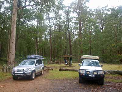
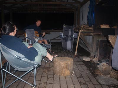
| Here we are set up at the Brushy Mountain Camping Area | Inside the shelter shed at the Brushy Mountain Camping Area |
 |
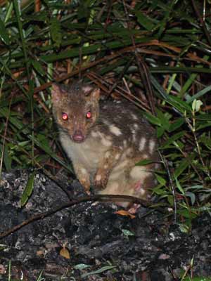
| A very cute juvenile tiger quoll at the camping area |
The camping area looks like a bomb, or rather, a flood has hit it. It has water everywhere and the ground looks in poor condition. There is a huge motor home here and the owner, Alan, is having a glass of red. He tells us that last night it rained so much the creek adjacent to the camping area overflowed and washed right across the whole area. The water was at least 150 mm deep. It washed away the fire in the shelter, as well as all the dirt off the top of the ground and forced some people sleeping in swags on the shelter floor to move to the top of the tables.
We set up our tents so that we back onto the shelter, meaning we can easily get stuff from the cars. We settle down inside the shelter, adding some of our wood to the fire and have a very deserved drink. As we have a drink, Alan tells us to look out for a tiger quoll. These are small marsupials that used to be known as tiger cats (there is also the eastern quoll). We soon see it and for the rest of the night, it darts in and around the shelter looking for food (they do not like rice it seems). They are quite rare and people seldom see them. Kelly and I saw an eastern quoll at Cradle Mountain in Tasmania in February 2008.
The camping area would be quite nice if it was not so wet. As well as the shelter shed, there are many fireplaces and some tables. There is also a toilet and the only rubbish pit I have seen still in a national park for about 10 years. There is room for at least 20 to 30 vehicles I reckon.
Over some drinks, Alan tells us he was a farmer. About 10 years ago he discovered that he had broken his hip many years earlier and had to have a hip replacement. He decided to retire, so he sold the farm and purchase the motor home. This has been his home for the past seven and a half years. He has it all set up and he reckons it is more comfortable than most normal homes.
Kelly cooks up a chicken and cashews stir fry with rice and after dinner, we sit in front of the fire for a while chatting while it continues to rain. It is a relatively late night for us when camping, probably 10:30 pm when we go to bed.
Kilometres: 280 kilometres
Weather: Raining, maximum of 27ÂșC in Wauchope but about 22ÂșC elsewhere and down to 17ÂșC up higher
For the next part of this trip, click here.
| 
 v6.00.307 © 2003-2005