|
For the first part of this trip, click here.
 |
Our route as recorded by our GPS from Border Ranges NP (top right) to Boonoo Boonoo NP (top left)
Bald Rock NP far left, Peacock Creek middle
|
Day 6 - Tuesday 27 December 2011 - Sheepstation Creek Camping Area, Border Ranges National Park to Peacock Creek Camping Area, Richmond Ranges National Park
We get up at 8 am and have breakfast. It is quite warm at 19ºC at this time but overcast. We leave at 9:30 am. We head out to the south-west and come out onto the Summerland Way at Wiangaree. We stop in at the general store which is called the Wiangaree Ramada! This is an amazing little store, which sells coffee, beer, take-away food as well as basic goods.
In addition, there is an amazing collection of old signs and food stuffs on the wall of the store. Well worth stopping in to have a look as you go past. We purchase a paper and were looking for some tea towels as we have forgotten all ours at home! However, they did not have any. There is also a nice little picnic area out front.
 | 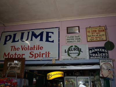 |
| The Wiangaree Store | Some of the artefacts inside the Wiangaree Store |
We continue our trip by going up the Summerland Way towards Queensland. Our plan this morning is to travel through Toonumbar National Park and then probably further south to Richmond Ranges National Park. We pass through Grevillia. This is an old mining town that has heaps of cute little timber houses.
It is 26 kilometres from Wiangaree to the turn-off for Toonumbar National Park. Unfortunately there is no sign indicating that there is a national park here. The road is called Coxs Road. This road goes through private properties before entering the national park. As you climb this road, there are great views to the north of a strange looking mountain. This is Mount Lindsay. It is shaped a bit like a huge mesa. Mount Lindsay is located right on the border of New South Wales and Queensland.
 |  |
This fallen tree on Coxs Road nearly
blocked the whole road | Mt Lindsay from Coxs Road |
As we enter the national park there is a huge tree fallen across the road. Luckily there is a space to get past as someone has already broken off the top branches and made space to get past. The road continues to rise, getting to 837 metres a short distance inside the park. Here the temperature has dropped to 21ºC compared to the 28ºC down on the Summerland Way. In this area the name of the road changes, at least on my GPS, to Cob-o-Corn Road. Along here Kelly spots a regent bower bird, a brilliant gold and black bird.
Soon we see a skinny black dog. It starts running along the road in front of us and does this for a number of kilometres. We come to an intersection. This is Tonnumbar Forest Road which leads to Sherwood Lookout. The dog disappears into the bush here. At the intersection there is a very old sign about the 1968 bushfires. Very poor English makes it hard to actually understand the point of the sign.
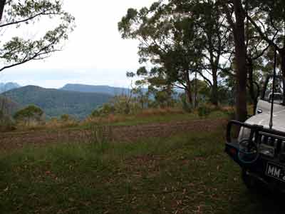 |  |
| The view of Mt Lindsay (far left) from Sherwood Lookout | You could camp here at Sherwood Lookout |
It is 13 kilometres from the main road to this intersection. It is only two kilometres to the lookout and we get there at 10:55 am. This is a very old state forest facility (it is now national park) with a table, timber barbecue and a water tank. There is space for a few cars/tents to camp and there is no sign prohibiting this. It would be a nice spot to camp.
As can be appreciated, there is a lookout here. This gives views north to Mount Lindsay. As mentioned, this is off on the border. It is 1,194 metres high and the lookout is 792 metres. We stop here and have morning tea.
The track that leads to the lookout, Toonumbar Forest Road continues on past the lookout. A little later we come across a couple who have a detailed forestry map and it shows that this road goes all the way to Rukenvale on the Summerland Way and is open. Why is it not advertised as a possible entry?
We head off at 11:20 am and go back to the intersection and then head south. Just two kilometres along is another lookout. This is called Murray Scrub Lookout. However, the lookout is roped off as it appears some tree roots have been dug up that were affecting the platform but the work has not been complete. There are views to the west from here.
We keep going and the road starts to drop down into a valley. Just after noon we come to the turn-off to Iron Pot Creek Camping Area. It is just over 10 kilometres from the Sherwood Lookout intersection to the turn-off to the camping area. It is about 5.8 kilometres from here to the camping area.
This is a very nice camping area with toilets, a shelter shed, tables and barbecues. It is not huge, but fairly nicely set out. Nearby there is a picnic area which also has tables, hut and I think a toilet. Both are located along a creek, but the picnic area is closer and it also appears a much nicer spot. We decide to stop and have lunch here. There are also some goannas walking around the picnic area.
 |  |
| The view from Murrays Scrub Lookout | Iron Pot Creek Picnic Area |
We head off after lunch at 12:35 pm. Our plan now is that we will head further south to Toonumbar Dam. We have been told that there is a camping area along the shores of the dam. It is about 25 kilometres to the dam camping area at Bells Bay. We find that this would be a nice spot but it is very crowded in the holidays. During a weekday outside holidays, I would expect it to be quite empty. Back near the dam wall there is a very nice picnic area. There is no sign saying that camping is prohibited here, but it is close to an accommodation lodge and I am sure they would object. It is certainly not permitted on the other side of the dam.
We revert to our original plan and continue south towards Richmond Ranges National Park. Funnily the road is called Iron Pot Creek Road. This is because the dam is on Iron Pot Creek. It is 10 kilometres along this road to the intersection with Peacock Creek Road. Here we turn right and three kilometres down the road we come to Peacock Creek Camping Area.
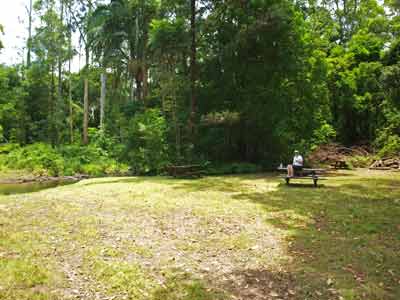
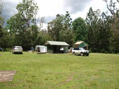
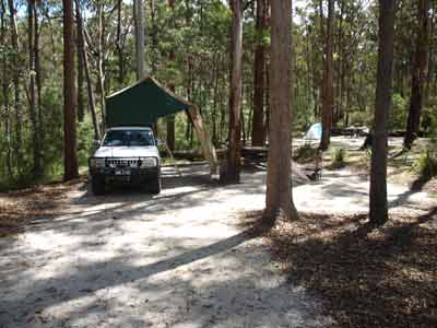
We arrive there at 1:50 pm and have a look. There are a few people camped here. Kelly wants to look at a couple of tracks that she saw as we came along the road as these seem to go down to the creek. We go back a bit and find one of the tracks. It leads down to near the creek and circles back, coming out on the road again adjacent to the camping area. So much for that. We go to the camping area and decide to stay. It is now 2:00 pm. It is located at S28º 39' 35.8" E152º 42' 57.1" using WGS84 as the datum.
There are five vehicles here. The camping area is an open grassed area, with a nice shelter shed and some timber barbecues. There are also toilets. We decide to back up towards the front of the shelter as it is looking like rain. The other groups have set up substantial tarps etc so we are not hogging the shelter.
We read for the afternoon and at 4 pm I start the fire. I am using the fireplace in the shelter and we are having a roast chicken. One of the blokes camped near is also doing a roast. He is cooking lamb but using a metal stove type thing that holds a large coconut fibre heat bead. This takes over two hours to cook at a much lower temperature.
 |  |
| Peacock Creek Camping Area | Some of the hail that fell |
This bloke and four other vehicles are together. Two are near identical Nissan utes with slip-on campers which are owned by twin brothers from Casino. The one doing the cooking lost his wife less than three months ago - this was her favourite camp site. With them is the other brother's daughter (his wife hates camping) and the deceased sister's sister and her husband. It is very sad to later hear the story about how he was about to retire and had set up the vehicle to travel Australia only to have her get ill and die very quickly. Just shows you should never put off retirement if you can.
Anyway, shortly after starting the fire, we see very dark clouds coming from the south-west and start to hear thunder. Soon it is one continuous rolling thunder, not individual claps. At 4:40 pm a sudden very loud sound is heard and within 30 seconds it is hailing. This is not small hail, it is huge. Kelly and I decide to drop the Shippshape tent so that lying flat its tougher outer shell is the only thing visible.
We rush out and while I drop the pegs etc holding it, Kelly uses the ladder to pull the tent down. She gets soaked by the rain that has already fallen on the tent top and I get hit in the head by one large hailstone. We rush back to the shelter where some of the other people are now. The early hail is the size of golf balls, although this size soon stops. The hail continues, now the size of your thumb nail. It is also pouring rain.
Then, all of a sudden, the wind starts blowing a gale. It was already strong, but now the wind is so strong the rain and hail are coming right into the shelter from one direction. Within a few minutes, the wind changes and it is coming from the totally opposite direction. We are pretty well soaked, although we manage to move things that need to be kept dry to spots that mean they remain mostly dry.
Within 10 minutes the hail has stopped and within 15 minutes it is totally gone. What a storm! Kelly and I pull up the Shippshape and discover that some water has leaked in via the not properly closed tent. It is not too bad and I use a towel to dry the bits of blanket and bedding that is wet. The only other casualty for us is that Kelly tore her shorts when rushing around. One of the Nissans ends up with some small dents on the bonnet. As far as I can see, we have suffered no damage to the car.
We clean up and then I set up the hot shower. At 5 pm we take turns to have nice, hot showers. You can get water from Peacock Creek by walking out the short distance to the main road and about 50 metres down there is a causeway. After this, we watch as the birds return. There are heaps here, including superb blue wrens, up to 10 at a time hopping and flitting around the grassy lawn. There are also some goannas and later in the night we will hear boobook owls and see a small marsupial mouse that lives in the chimney of the shelter.
The fire for the roast is going good and Kelly is also planning to cook sticky date puddings so she prepares these. I put the chicken on at 6:30 pm and it is cooked, with vegetables, by just after 7:30 pm. Later, Kelly cooks the sticky date puddings and makes some caramel sauce. All was excellent. We read more and go to bed about 10:00 pm.
Weather: Varied, sunny and overcast and heavy rain and hail, max 28ºC
Arrived: peacock Creek Camping Area, Richmond Ranges National Park Time: 2:00 pm Distance: 118 kilometres
Day 7 - Wednesday 28 December 2011 - Peacock Creek Camping Area, Richmond Ranges National Park to Bald Rock National Park
Weather: Overcast, 15.2ºC minimum
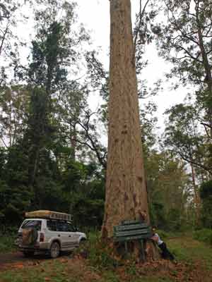 |
| Old Spotty, the spotted gum |
We are up at 8:00 am as we do not have to rush too much. The ground is still very wet from last night's hail and rain storm. We have breakfast and pack up, waiting as long as we can for the tent to dry as much as possible. We leave at 9:30 am.
We have decided to take the access road to the south that runs along the length of Richmond Ranges National Park. This passes along Cambridge Plateau. The track comes off from near the intersection where we joined Peacock Creek Road yesterday afternoon, about three kilometres back up the road. It is a very good track, easy to drive. It follows the ridge top and sticks to about 450 to 550 metres.
The trees along here are huge, with 8.2 kilometres from the intersection an enormous spotted gum being sign-posted. It is at least 200 to 300 years old. You only need a couple of minutes to look at it. We continue south and we see some nice views out to the left and there are some huts as well as we pass private property. There are a lot of spots along here where you could camp, in fact we come across a bloke in a Discovery who came into the camping area last evening but left.
At just after 10:10 am we come to the Cambridge Plateau Picnic Area. This is 23 kilometres from Peacock Creek Camping Area. This is a really nice and quite large picnic area. To be honest, it appears to be designed as a camping area as there are spots well off the road with timber barbecues and even tables. There is no sign saying you cannot camp here. It is located at S28º 48' 29.4" E152º 44' 39.4" using WGS84 as the datum.
As well as the things mentioned above, there are other picnic tables, shelter, timber barbecues and toilets. There are excellent views as well to the east. We leave at just after 10:20 am and less than six kilometres later we start descending the ridge and also exit the park into farming land. The road continues through the properties till it reaches the Bruxner Highway.
This road has lots of cattle on it, so much so that we cannot help but keep running over cow poo. We reach the highway at 10:40 am, having taken 70 minutes to travel the 36 kilometres (including a stop at the picnic area). There is a lookout near the intersection so we drive up there and have morning tea here. You could also camp here in a roof top tent or camper. We notice that the car now stinks of cow poo. It is stuck all over the tyres and under the mudguards.
 |  |
| Cambridge Plateau Picnic Area | Cambridge Plateau Picnic Area |
We are back on the road at 11:05 am. We are now heading for Tenterfield. We cross the Clarence River over a long single lane timber bridge. I am amazed that a bridge like this still exists on this highway. We arrive at Tenterfield at 12:20 pm, taking 75 minutes to cover the 93 kilometres.
We need to go food shopping here as well as get some more fresh water. We find a BiLo just off the main street. We need bread as well as some steak (we forgot ours) as well as tea towels (again, forgotten) and a few other things. I also go to the newsagents and purchase a paper and, more importantly, purchase a ticket in the Lotto on New Year's Eve which is $29 million (of course we do not win). There is also a tap in the toilets at the supermarket's parking area where I fill up all our water.
 |  |
| On the top of the rocks at Thunderbolts Hideout | Me inside a part of Thunderbolts Hideout |
 |  |
| Kelly inside Thunderbolts Hideout | Kelly at Thunderbolts Hideout |
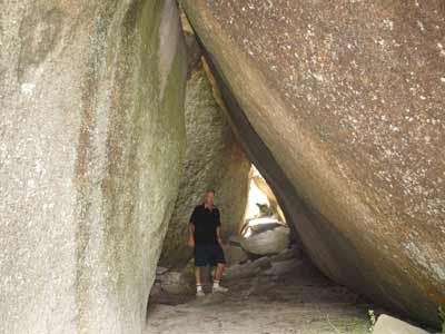
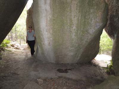
At 12:55 pm we head north out of town. We take the Mount Lindsay Way turn-off just north of town and 12 kilometres along we stop at Thunderbolts Hideout. This is said to be one of the hiding places of the bushranger Captain Thunderbolt, real name Fred Ward. After escaping from Cockatoo Island in Sydney Harbour on 11 September 1863, Ward headed to the New England area and became a bushranger. After a robbery on 21 December 1863, he called himself Captain Thunderbolt. Over the next six and a half years, Thunderbolt ranged across the north-eastern part of New South Wales. One of the places he visited was north of Tenterfield, where this spot was used as a hide out. Thunderbolt was killed by Constable Alexander Walker at Kentucky Creek near Uralla on 25 May 1870.
It is now 1:05 pm so we have lunch here and then walk to the hiding place. It is only just off the road and if the old road came along this way back in the 1860s, then you can see why he picked this spot. The large boulders make excellent caves and a series of canyons that could be easily defended. It is an interesting place to examine.
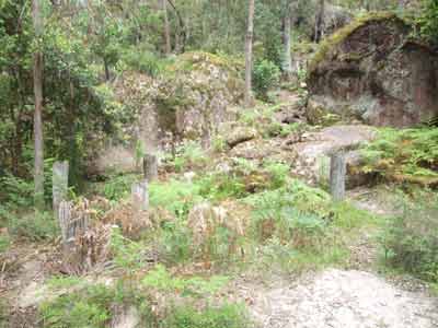 | 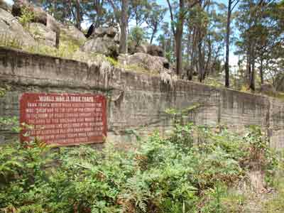 |
| The remains of the Tenterfield Tank Traps | The retaining wall at the Tenterfield Tank Traps |
Only a kilometre further along are the Tenterfield Tank Traps. These are World War II structures erected here and also over on the Bruxner Highway to block the southward movement of the Japanese if they ever invaded. The road here goes through a sort of pass and on the western side of the road there are a series of wooden poles in the ground. I have not been able to find out what they might have looked like when built, but it seems they may have been some sort of entrapment device wherein a tank attempted to drive over it and then fell into the middle and got stuck. It is said that these were part of the "Brisbane Line", but whether this actually existed is now hotly disputed (Google it). It is worth stopping and having a look.
We have decided to go to Bald Rock National Park today and tomorrow to Boonoo Boonoo National Park. We pass by the entrance to Boonoo Boonoo first and then about 30 kilometres from Tenterfield we turn off onto the Bald Rock access road. This leads to Bald Rock, the largest granite rock in Australia. It is 750 metres long, 500 metres wide and 200 metres high. It is not larger than Uluru (Ayers Rock) as sometimes stated. Uluru is 3000 metres long, 1000 metres wide and 348 metres high. We plan to climb Bald Rock this afternoon.
 |  |
| The Bald Rock Camping Area | The first part of the walk to the summit of Bald Rock |
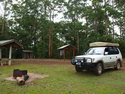
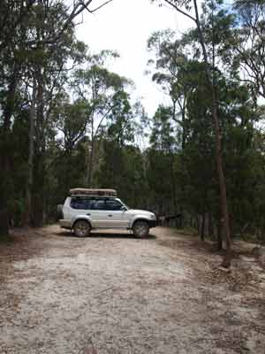
We arrive at the parking area at 2:00 pm and decide to go to the camping area first to find a spot while it is early (we have been caught out before). We find a nice spot and set up our Shippshape. The camping area has toilets, a shelter shed, gas barbecues, wood barbecues, tables and water piped to various locations. The camp sites are individual spots, suitable for tents, roof-top tents and camper trailers. A well set out camping area. The cost is $7 for the car and $7 a person (although the sign actually said $5 a night).
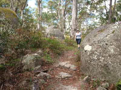
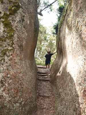
It is only a minute or so back to the parking area where the walk starts. There are two ways up, the easy way and the hard way. We decide to go via the easy way and come back the hard way (I would recommend this as the easy way is the more scenic route). There are similar huge boulders like at Thunderbolts Hideout and they also make tunnels and canyons. Kids will have a great time during this part of the walk.
 |  |
| The Bald Rock Summit Walk has lots of interesting sections | Looking out from inside the tunnel at left |
 |  |
| Me and a narrow section of the walk | Some more of the boulders on the walk
to the summit of Bald Rock |
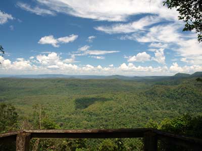
It takes us just under an hour to get to the top. It is an easy walk and the cool (20ºC) temperature makes it comfortable. There are 360º views from the trig point, including Girraween National Park in Queensland.
 |
| A panoramic photo from near the top of Bald Rock looking north |
We come back via the hard way which includes a very steep walk down the rock face. It is not too bad coming back this way, but you need to take care. It takes us one and a half hours for the trip up and back, including time spent admiring the view. The signs at the bottom variously say it is 2 or 3 hours and other signs say the distance is 6 or 9 kilometres. Not sure how this was recorded, but there is obviously a problem here!
We go back to the camping area and have a cuppa and read for a while. We set up the shower and have nice hot showers using a full 10 litres each. After this we have drinks and nibblies and two grey kangaroos visit.
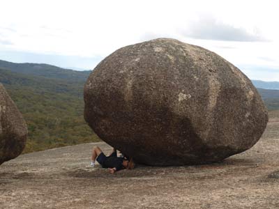 | 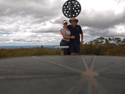 |
| A boulder about to crush me :-) | Kelly and I at the summit of Bald Rock |
 | 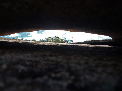 |
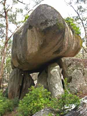
| The view from above the steep section of the walk | Looking through a granite onion |
We still have a problem with the car. It stinks! This morning when we came through the farms after leaving Richmond Ranges National Park we could not avoid the cow patties and each of the mud guards is full of dried cow shit. It smells very bad. However, not much we can do about it now.
We have a nice chilli peanut lamb and rice dinner and left over sticky date pudding. Excellent as always Kel!
It is a lot cooler tonight as we are at 1,122 metres. It is surprisingly high in this area as you are not on the top of any obvious hills or mountains. At 1:30 am it rains for about 20 minutes.
Weather: Overcast and sunny, max28ºC
Arrived: Bald Rock National Park Time: 2:00 pm Distance: 164 kilometres
Day 8 - Thursday 29 December 2012 - Bald Rock National Park to Boonoo Boonoo National Park
Weather: Sunny, 13.1ºC minimum
When we get up at 8 am it is 14ºC and sunny, despite the rain overnight. We take our time as we are not going far today. We leave at 9:30 am and head back out to Mount Lindsay Way. We head back towards Tenterfield. Our plan is to first visit Basket Swamp National Park and then go to Boonoo Boonoo National Park.
We stop just before Boonoo Boonoo River and Kelly uses a stick to knock all the cow dung off the wheel arches using a stick. At the same time, I cut some firewood for tonight. This only takes us 10 minutes. It is 19 kilometres from the Bald Rock National Park camping area to the run-off for Basket Swam National Park. This is called Lindrook Road. Four kilometres along we turn right into Woolool Wooloolni Road (there is a sign to the park). Two kilometres down we turn left into Basket Swamp Road and then three kilometres along right into Basket Swamp Fire Trail. It is 11 kilometres from the main road to the falls.
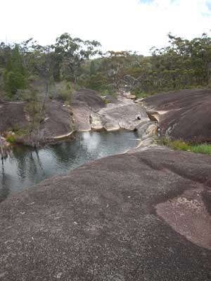
Basket Swamp Falls are on Basket Swamp Creek. It is a bit of a disappointment as there is absolutely no infrastructure at the falls. No signs, no picnic area, nothing. What's more, you cannot drive to the spot that gives good views of the falls and have to walk down a very steep and slippery fire trail. First we have a look at the top of the falls. There are some nice swimming holes here and in one spot, there are two jets of water coming out from a higher up hole. Interesting!
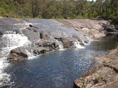 | 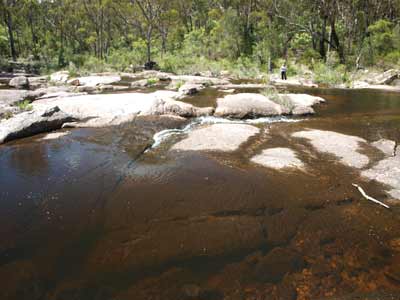 |
| One of the pools above Basket Swamp Falls | Looking downstream from the base
of Basket Swamp Falls |
We walk about 200 metres down to the lower falls but even then it is a bit of a bush-bash to get to the creek. There are more pools here and a nice view of the waterfalls. Back at the car park there is space for a couple of roof-top tents, but I would not bother camping here as there are other nearby places that are nicer.
Three kilometres back up the road there is a flooded quarry. There is someone camping here and it is not a bad spot as the water is quite clean and it would be a nice spot to cool down. There is lots of space to camp for even the largest vehicles. Back at Basket Swamp Road, we turn right and only 400 metres along there is a nice camping area off to the right. It is sheltered amongst the trees and near Basket Swamp Creek. There are lots of spaces to camp.
We stop at the creek as it is 11:15 am and we have morning tea. It is a nice day, sunny and 25ºC. We leave at 11:30 am. We have decided to travel to Boonoo Boonoo Falls via the tracks in the state forest. From our location we travel along Basket Swamp Road (as it is in our GPS but it is signposted Lindrook Road). Two kilometres from the creek we turn left into Lindrook Road (both GPS and sign) and 1.5 kilometres along we turn right into a fire trail. I am not sure what this is called, but it does not have a name on our GPS.
 |  |
| The lower section of Basket Swamp Falls | Basket Swamp Creek where the road crosses it |
This is a good track and we are making good time at about 20 km/h. However, 1.5 kilometres along we come to a problem. There is a large tree right across the road, totally blocking forward progress. It is now 11:36 am. It is quite a way back to the main road and I cannot be bothered doing this, so we decide to remove the tree. It has many branches and is pretty big.
I get the chainsaw out and start work. I have to cut the main trunk from below to ensure that it does not jam the saw. This is quickly done. I then have to cut a lot of other smaller branches that are blocking the road past the main trunk. There is also a higher extension from the trunk that needs to be cut. Once this is all done, I run out the winch cable and wrap it around the right-hand side of the trunk. I winch the tree back towards the car and it twists as I plan it to so that it is now facing the side of the road. Kelly and I roll it off to the side of the road.
 |  |
| Cutting the upper branch of the tree that blocked the road | Kelly driving around the remains of the tree |
It takes a few more minutes to remove the smaller branches and make it all good. Kelly is driving so she brings the car closer to the tree. I have probably made the gap between the two parts of the tree a little tight, but with some direction and a little pushing of another part of the tree with the right wheel, she gets past okay. We are back on the road at 11:55 am, having being stopped for almost 20 minutes.
One kilometre along there is a gate which says authorised vehicles only and four more kilometres another gate. These have no locks. Just past this gate we turn left onto Colongon Road. There is no sign at this end saying this track is authorised vehicles only. Another four kilometres brings us to Link Road. We turn left and then two kilometres along come to Boonoo Boonoo Falls Road, the main road into the national park. We turn right and at 12:20 pm arrive at Boonoo Boonoo Falls.
There are shelter sheds, gas barbecues and tables here, a very nice spot to picnic. There are quite a few cars and people having picnics. We walk to the falls's lookout. This is not too far along a nice track. There are great views of the top part of the falls which drop quite a height. The river enters a large gorge below the falls, very spectacular.
 |  |
| Boonoo Boonoo Falls from the lookout | Boonoo Boonoo River next to Platypus Hole
Picnic Area (presumably this is the hole) |
We only spend 20 minutes here. There are places to swim at the top of the falls but we want to get back to the camping area to get a spot. We head back the way we came in (Boonoo Boonoo Falls Road ). Just before the Cypress Camping Area there is the Platypus Hole Picnic Area. This has an excellent swimming hole and one table. It is not as nice a picnic area as the one at the falls.
We go to the camping area and after our usual complete circuit, decide on a spot. The camping area is fairly full, although there are still quite a few spots. Most of the sites with tents are currently not occupied, the people are obviously out bushwalking or sightseeing elsewhere. As per most of the camping areas in this part of NSW, there is a shelter shed with gas barbecues (although it is not very central for campers), tables, very good wood barbecues and toilets. It is now 12:47 pm.
All the spots are individual sites, but some have the capacity to take a few vehicles. Our spot is small but quite nice. We have a table and barbecue. We have lunch and then go for a short walk to the Platypus Hole. We decide to have a swim later as we plan to do a walk first.
 |  |
| Our camp site at Cypress Camping Area | The two boilers at Murrays Creek |
We decide to walk to the Murrays Picnic Area which is two kilometres down the road. This site is where there was gold mining back in the 1800s. We walk along the road and are surprised at the number of cars coming into the park. Along the way we see a powerful owl in a tree next to the road.
The Murrays Picnic Area is in very poor condition and consists of a single table on uneven ground and no fireplace or toilet. At this spot a creek joins the Boonoo Boonoo River. The creek appears to be where a system was set up to sluice gold. There are some rock walls and possibly some modification of the creek through the rock. Back up near the road there are two small boilers. Some interpretation signs would be nice.
 |  |
One of the pools at Murrays Creek below
the structure in the photo at right | The retaining wall and cutting in Murrays Creek |
According to the park brochure, there is a hut marked near here on the other side of the road along Girder Fire Trail. We cut across the field to it and find that the hut seems to be a more recently built one. It looks like this was the residence at some time of the NPWS field officer as there is a NPWS workshop right next to it. This hut now can be rented and there were a couple here. The map seems to show that the track we walked in on loops to the main road, but this is not the case. We look behind the workshop and see a rough track down to the Girder Fire Trail. We take this and soon are back on Boonoo Boonoo Falls Road.
We walk back to the camping area, taking 100 minutes to do the walk. By now we are hot and sweaty so we decide to go for a swim in the river. We walk to the Platypus Hole and have a swim. It is cool in the water, but very refreshing.
We are having pizza for dinner, so after the swim I start preparing for this. I put on timber for a fire and then make the pizza dough. I need to do this early to let it rise a little. Kelly cuts the meat and other things for the toppings and then I roll out the bases and prepare it all. We also have some garlic bread for an entree. Tonight we are making chicken pizza and some meat pizzas, with salami, ham and other bits.
By now it is drink time and I have a beer as I complete the pizzas. The camp oven is on heating and I put the garlic bread on first. After this I cook the pizzas, first a shared one, then an individual one for Kelly and then one for me. Finally, another shared one. The pizzas are small, and one full one is enough for dinner. We end up with half of each of the individual ones left over as well as a full shared one. This will be lunch tomorrow. I really love pizzas out in the bush.
It is a lot colder tonight, about 13ºC, with a sort of very light mist or drizzle. We read after dinner and then go to bed about 9 pm and read some more.
Weather: Sunny, max 26ºC
Arrived: Boonoo Boonoo National Park Time: 12:47 pm Distance: 57 kilometres
For the next part of this trip, click here.
|  v6.00.307 © 2003-2005

