|
The only times I have been to Fraser Island have been when we sailed past in our yacht Catlypso in 2015 and 2017. Both times we ended up anchored at Garys Anchorage on the south-western corner of the island and Kingfisher Resort on the western side. Kelly went there about 1995 or so.
As we did not go sailing in 2017 and Kelly was working full time, we decide to go to Fraser Island in late July and early August 2018 for a one week holiday. We also decide to take Kelly's Mum, Mary, her sister Nicole and Nicole's baby, Estelle. Because of this, it means we can not camp, so Kelly looks at renting houses on the island. Till she did this, I did not even realise that there were private houses there.
We end up renting a house right overlooking the beach. The house is at Poyungan Rocks. This is about half way up the eastern side between Eurong and Happy Valley. More about this later.
As Kelly only has limited time off work, the plan is for me to drive to Queensland and then collect Kelly and go to Fraser Island. I decide that I will do some scuba diving on the way up so I plan a dive trip with members of our dive club for South West Rocks. In the end, Kelly's Mum, who lives on the Gold Coast, is going to be down in Sydney as she is going to go to the snow with Nicole two weeks before our trip and then look after Estelle the week before.
We end up deciding that they will all fly from Sydney on the day that we are to move into the house and I will collect them at the airport. The best place to do this is not the Gold Coast, but the Sunshine Coast, as it means we have less distance to drive after I will collect them.
Tuesday 24 July 2018 - Sydney to South West Rocks
Of course we are going to use our new Toyota LandCruiser 200 series four wheel drive as you must have a proper four wheel drive to drive anywhere on Fraser Island. I leave Sydney about 9:00 am and drive to South West Rocks, about 480 kilometres up the north coast from our house. I arrive there at about 3:00 pm after a quite good run.
The LandCruiser is quite well loaded up, as not only do I have all my dive gear, I have our Engel car fridge, a huge amount of clothes, food and drink as well as some things I have to drop off at Kelly's Mum's place at the Gold Coast.
Distance: 480 km
Wednesday 25 and Thursday 26 July 2018 - South West Rocks
We dive both days, with plenty of grey nurse sharks at Fish Rock and excellent conditions. We do a couple of different dives, the water is a bit cool but clean. We also have plenty of humpback whales near the boat on the way out as well as in between the dives at Fish Rock.
 |  |
| A small grey nurse shark in the main gutter | Another grey nurse shark |
On the Wednesday I go up to Smoky Cape and use the Mavic Air drone that Kelly bought me for my birthday two weeks earlier. I take some video and photos up there. On the Thursday I use it on the main beach to get shots of Trial Bay. See the photos below.
Friday 27 July 2018 - South West Rocks to Surfers Paradise
The conditions the past two days were so good, Jason and I decide to dive again while all the rest have headed off. We have another two great dives, more sharks, more whales seen on the surface and plenty of fish.
 |  |
| The South West Rocks township | Smoky Cape Lighthouse with Fish Rock in the background |
We get back from the dive at about 1:45 pm. I quickly pack my dive gear away (I am going to wash it later) into the LandCruiser and just after 2:00 pm I leave and head north. More new sections of the Pacific Highway are open, so these sections mean I can sit on 110 km/h. However, from Grafton to Ballina, about 140 kilometres, is quite slow going as nearly the whole section is almost totally roadworks with a maximum of 80 km/h permitted.
I end up at Mary's place just after 7:00 pm. It has taken me about five hours with a couple of stops, including a refuel just before I get there. I wash my dive gear, unload all the things I am leaving here and then relax with a few beers and some dinner. It has been a big day!
Distance: 420 km. Fuel: 100.6 litres for 929 km Economy: 10.8 l/100 km
Saturday 28 July 2018 - Surfers Paradise to Fraser Island
I get up early and head off shortly after 7:00 am. I have to drive north to the Sunshine Coast Airport which is near Maroochydore. I also have to do a lot of shopping for food. Kelly and the others are arriving about 11:00 am, so I need to be finished by about then to be at the airport once they have their bags.
I arrive at Maroochydore at about 9:30 am and head straight to Aldi. Here I get the vast majority of things we need. We have to take basically all our food for the whole week. We have planned on seven lunches and dinners, even though we plan to eat dinner out one night and lunch out a couple of times. We have to do this as if the weather is bad, we might not be able to drive on the beach to where the resorts are located.
After Aldi, I go to the nearby Woolworths and get the remaining things. Just as I load everything into the fridge and car, Kelly calls. It is 11:30 am and they are waiting for their bags at the carousel. I head straight there and arrive just after they get to the pick up point. We load the bags aboard (I already have the car seat for Estelle and lots of her things). We head off towards Gympie, taking a very long route because of the stupid GPS in the LandCruiser.
At Gympie we go to the shops as there are a few things we have forgotten. We then go to the local park where we have lunch. After a short break we head towards the coast at Rainbow Beach. Here we refuel. This means we should be able to go the whole week on Fraser Island without refueling there at the exorbitant prices.
We drive the short distance to Inskip Point. Here Kelly and I deflate the tyres to 20 psi. We drive onto the beach and out to where the barge lands. We are first in the queue. The sand here is very soft, we pass a Troop Carrier bogged coming our way and another 4WD and trailer going the opposite direction. We handle it easily.
The barge arrives shortly after but we have to wait for an almost full load before we head over to Fraser Island. We have been warned by some people we were speaking to at Inskip that the sand on the other side is very soft too. However, we have no problem at all.
The tide is up a bit, but not so far that we have to use the southern inland track around Hook Point. We have to stay high where the sand is very dry and soft. I am using the low speed torque converter lockup which locks at about 35 km/h. This certainly improves our fuel economy and gives lower transmission temperatures (we can see these via a Scangauge 2).
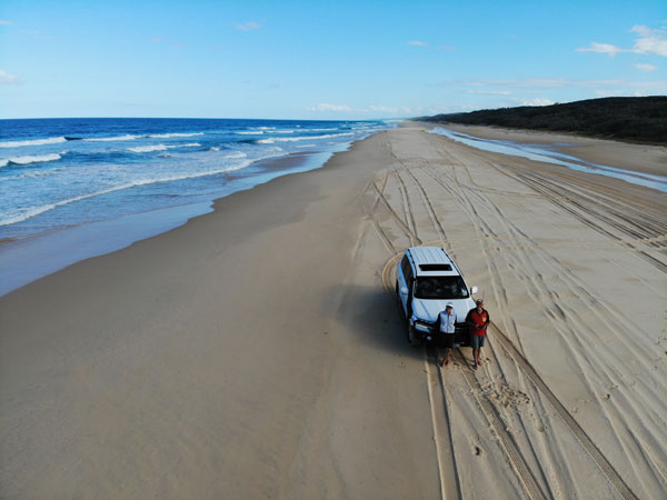
We have a very good run up the beach. We sit on a maximum of 60 to 75 km/h, but as others want to go faster, we let them overtake us. We arrive at the house at Poyungan Rocks at about 4:30 pm. It has taken less than an hour to travel the 46 kilometres from the barge.
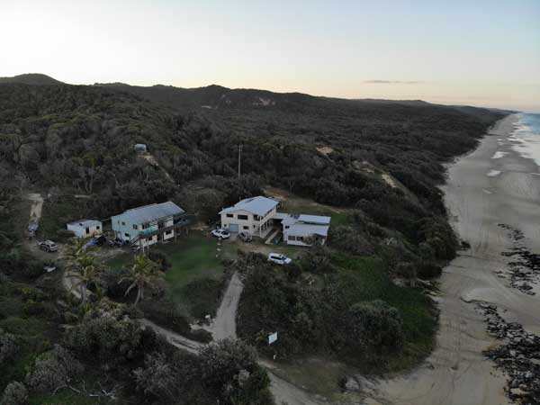 | 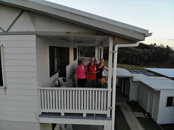 |
| Poyangan Rocks. Our place is the top of the two storey place in middle | On the verandah of the house |
Wow, the house is very nice and well located as you can see from the photographs below. There are three places right where we are and all are occupied (as is the caretakers accommodation). We unload the car, pack everything away and have a quick look around. The only power comes from solar panels and batteries, although there is a backup generator. Of course this means no hair dryers for the girls, no electric toaster etc. Cooking is by gas.
We then have some nibblies and drinks overlooking the water. What a life! Kelly cooks a nice dinner too!
Distance: 413 km Fuel: 41.1 litres for 347 km Economy: 11.8 l/100 km
Sunday 29 July 2018 - Fraser Island - Eli Creek and SS Maheno
We have decided to have a relaxing start to the day, with our only excursion being to drive along the beach to the north. We have breakfast and then as it is so calm, I decide to use the drone. Soon I see a humpback whale coming from the south, very close (it seems) to the beach. Once it gets near our house, I send up the drone and head it out to sea. It is actually a lot further away than I think. I video and photograph the whale from a legal distance.
Once the whale has moved past us, I bring the drone back. I download the photos and am amazed to see that with the whale was a very tiny calf. Brilliant! This was not at all visible from the shore or even when looking at it live on the phone screen.
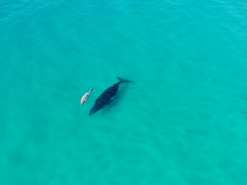 |
| The humpback whale and calf I photographed off our house at Poyangan Rocks |
After morning tea, we leave about 10:00 am. We drive along the beach to Happy Valley (9 km) where we have a look around. As well as the resort, there is a small store here and a pretty nice pub. We have a look at the menu as we probably will come here for dinner later in the week.
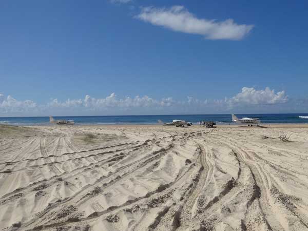
We then continue north to Eli Creek. We have a quick stop look around before continuing on (too many here at the moment). At Eli Creek there are aircraft on the beach. We will later figure out that the planes and some of the buses leapfrog each other. People get a flight from A to B while the buses go from A to B with other people on them. Then people swap from planes to buses and some from buses to planes and they all go from B to C. We see the planes many times every day.
We go to the wreck of the SS Maheno which is only a few kilometres north. At the wreck (which hit the beach 9 July 1935 while being towed to Asia to be scrapped) there are lots of people. Most are from buses and the backpacker 4WD tours. You can see the backpacker tour 4WDs in the photo below. They use old 80 series and 90 series LandCruisers mostly, with the backpackers taking turns to drive, lead by an owner driven vehicle (the white one in the middle). Some appear to be day trips and others multi-day overnight trips.
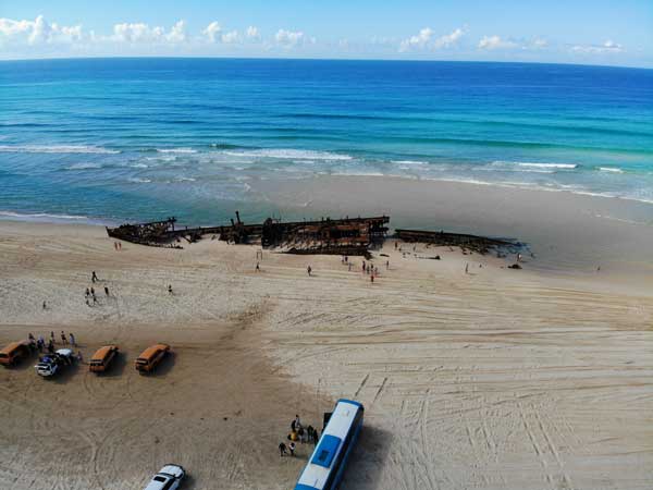 |  |
| The remains of the SS Maheno | The remains of the SS Maheno |
I set up my new Mavic Air drone and take some video footage as well as photos of the wreck. They come out great. However, when I go back to the car I notice that someone has stolen the rubber mat I put down on the sand for takeoffs and landings! I used this as the sand was dry and very fine to stop it being blown all over the drone. I think someone probably thought it was rubbish, but it was right next to our car.
We then head back towards Poyungan Rocks, stopping at Eli Creek for a swim. The water is crystal clear but very cool! It is too shallow to really swim in or even float down from where you can walk to. If you have a float you would be okay.
 | 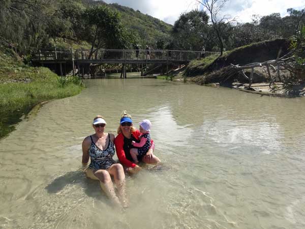 |
| The three planes on the beach at Eli Creek | Kelly, Nicole and Estelle in Eli Creek |
After this we drive back to our house for lunch. We spend the rest of the day here. I later go for an hour long walk along the beach. It is very relaxing and nice to walk on the beach in bare feet, something we have not been able to do really since our sailing trip in 2017.
Once again we have drinks and nibblies overlooking the beach before a nice barbecue dinner.
Distance: 420 km
Monday 30 July 2018 - Fraser Island - Indian Head, Waddy Point, Champagne Pools and SS Maheno
Today we are again heading north, this time a long way up the island. We are not going to the very northern end (Sandy Cape) as that is about 120 kilometres each way. We have another relaxed start to the day. We put things for lunch in the Engel, some drinks and after morning tea we head off at about 9:50 am. We again pass Happy Valley, Eli Creek and SS Maheno and then Cathedral Beach where there is another resort.
We have decided to do this trip today as the low tide is about lunch time which means we will have more beach to drive on than later in the week. The tides this week are not very high and the highest one is currently just after sunset. As such, the run along the beach is very easy. It is about 49 kilometres to Indian Head.
At Indian Head you have to go inland over the sand dunes to get around the headland. This is very soft sand but the Land Cruiser handles it easily. There is a very strong southerly blowing today, so when we get to Indian Head at about 10:15 am there are dozens of fishers parked on the beach in the protection of the head and the sand dunes. We stop here for a few minutes.
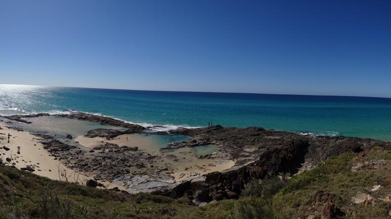 |
| Looking down on Champagne Pools from the walkway |
From here we drive along the beach towards Champagne Pools. Just before the pools, there is another headland and you have to again leave the beach. On some of these exits off the beach there are timber boards laid crossways to make the climb easier. We stop in the carpark and do the walk to Champagne Pools. There are two carparks and the track goes from one to the other, so you can do a loop.
There are great views back to Indian Head and further around, you look down onto the pools which are one of the most popular locations for tourists. We decide to stop here on the way back for a swim, but in the end we do not due to time constraints. We leave after about 15 minutes and drive along the internal track (north-west) to Orchid Beach. There is separate east bound track and a west bound track. This is a small village with a shop, houses and pub.
 |  |
| A photo looking back at Indian Head from Champagne Pools | Looking towards Orchid Beach from Waddy Point |
We decide to have lunch. Not finding a suitable spot here, we head back onto the beach and go east back towards Waddy Point which is due north of Champagne Pools. We drive right to the end where it is very protected from the wind. We sit on the beach and make some lunch. Estelle has a play on the sand and in the water. Kelly and I go onto the point which has had a recent hazard reduction burn. We spend some more time here before heading off just before 1:30 pm.
We head back the same way we came. Again, the sand on the inland tracks is very soft but we don't have a problem. By the time we are back on the main eastern beach the wind has dropped a lot from this morning. When we get to the wreck of the SS Maheno we stop as there are a lot less people here and I want to take some photographs of the wreck.
 | 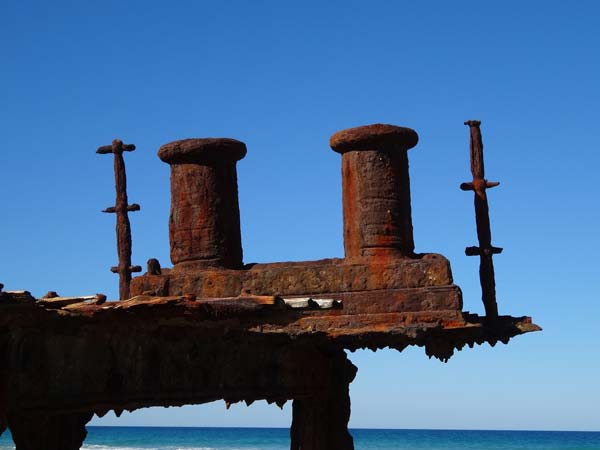 |
| The bow of the Maheno | One of the bollards on the wreck |
We leave after 10 minutes and head back to Poyungan Rocks, arriving there about 3:45 pm. It has been a fairly long day. We spend the rest of the day here, going for a long walk (at least I do). Once more we have drinks at sunset and then a nice dinner cooked again by Kelly.
Distance: 125 km
Tuesday 31 July 2018 - Fraser Island - Eurong, Central Station, Wanggoolba Point and Lake McKenzie
Today we plan to do an internal trip. This morning we see some more humpback whales from the verandah but when I try to get video of them I discover the water is very dirty compared to a few days ago. This is presumably because of the wind yesterday and the shallow water.
We head off about 8:30 am and go south along the beach to Eurong. This is 11 kilometres away. Here we stop at the bakery and get some fresh bread rolls as well as some pastries for morning tea. We also look at the hotel to see what the dinner menu looks like. We prefer Happy Valley, so will probably go there tomorrow night. We head inland along the sand track. Lots of the tracks are one way, so it is important that you take care to select the proper track.
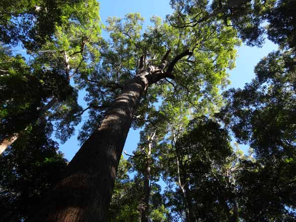 |  |
| One of the huge trees at Central Station Camping Area | A goanna at Lake McKenzie |
It can get a bit confusing on this track as there are plenty of cross-tracks and not all are well sign-posted. It is 9.5 kilometres to Central Station, so named presumably as it is very central to all the tracks on the island. We average about 20 km/h in the soft sand. We stop here for morning tea (it is 9:50 am). There are a couple of sections of a camping areas here. We drive around and have a look, very cool, under 13C at the moment and not much sun.
We have morning tea with the pastries, very nice. From here we head west along Wanggoolba Road to Wanggoolba Point. This is where one of the car barges from River Heads lands. We get there about 11:00 am. It is about 10 kilometres from Central Station. The barge arrives while we are here. We have passed by this spot while sailing in 2015 and 2017, so this is the reason I wanted to see it, but it was a bit of a waste of time. We head back to the Central Station area and notice that there is a picnic area here too.
 |
| Lake McKenzie from the drone |
Past here there are a choice of tracks to take. We take the one to the left which does not go past the camping area. We then take Northern Road which is a very scenic drive on a harder sand track through a nice forest. We pass through Pile Valley where some national park staff are cutting branches from very large trees. From here we go on Lake McKenzie Road which is one way towards the lake. We arrive at Lake McKenzie at 12:15 pm.
We have lunch in the picnic area where a large goanna strolls around, forcing the girls all up onto the seats! We then go to the beach and have a swim. I use the drone to get some photos and video. This really gives a much better perspective of the lake. We stay about 90 minutes before heading off.
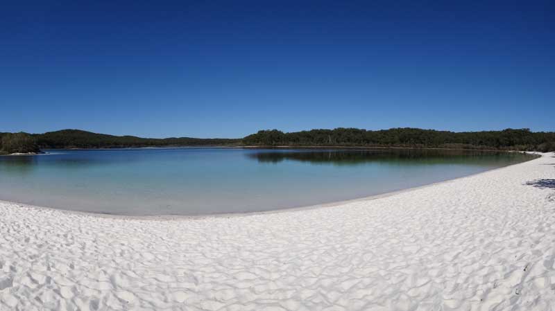 |
| A panoramic photograph of Lake McKenzie |
Because of the one way road, we have to go back either via Bennett Road to the north and then back to the east on Lake Wabby Road or take an unnamed road back towards Central Station Picnic Area. We decide to take Bennett Road so we see a different area.
As we get part way around the intersection of the three roads (Bennett, Lake McKenzie and unnamed roads), we have to stop as a Land Rover Discovery 1 is bogged in the middle of the track. We have to stop and help as we cannot get past (we would have stopped anyway). It is a hire car driven by a German couple with a young child. The husband gives it a go but all it does is spray sand everywhere. We asked if he has lower tyre pressures and he says we have. I get in and have a go, trying low range but still no good. We ask him to check the pressures again. They are 30 psi! Kelly gets our tyre gauge and we all drop the pressure to about 18 psi. I then get in the car and drive it straight out of the bog.
While we are here, a Mazda BT50 has pulled up behind the Land Rover. He has to go before we can get past but when he gets to the same spot, he gets bogged. The problem is lack of clearance. We trust that he has 20 psi like he says. I get the Land Cruiser and can get past him. We hook up a snatch strap and I pull him out without even really noticing that I have done it. He drives off the track to get around the boggy spot. We continue on.
 |
| Another photograph from the drone at Poyungan Rocks |
Once again, it is a very nice drive. It is 5.5 kilometres to the Northern Road which we cross over onto Lake Wabby Road. This continues to the east, then north and east again. It is 15.5 kilometres back to the beach. Just before dropping to the beach there is a lookout with views of Stonetool Sandblow, a large bare dune. I wanted to fly the drone here but it is too windy. We arrive back at Poyangun Rocks at about 3:00 pm. A very long but enjoyable day. We are surprised that Estelle has been very good all day, most of which has been strapped into her baby seat.
Each afternoon when we get back, I wash the car down to get rid of all the sand on and under it. I also, obviously make sure I get rid of all the salt on the body work and in the chassis. Luckily our place has its own bore and there is no limit on the amount of water we can use.
I go for another walk along the beach. I normally walk for about 30 or so minutes and then turn around. I meet lots of fishers on these walks. One afternoon I watched as one of the blokes in the house behind us hooks a fish and fights it up and down the beach. I give up watching when after 30 minutes he still seems no closer to getting it in. We later find out that it was a shovelnose ray, hopefully he let it go (I did not ask).
We have another nice evening with drinks on the verandah watching for whales and then dinner.
Distance: 125 km
Wednesday 1 August 2018 - Fraser Island - Southern Lakes Loop
Today we have another long day planned. We have breakfast and once we have loaded food and drinks into the car, we head off at about 8:30 am south to Eurong. We again stop at the bakery to get some pastries. After this we go to the rubbish disposal area which is a bit inland from the main village area. We get rid of our rubbish. Unfortunately there does not seem to be any recycling here at all, so Michael is collecting our beer cans etc to take home.
Today we take the same track as yesterday. We go past the Central Station Camping Area and pull into the picnic area at 9:30 am. We discovered last night that there is a boardwalk here so we decide to do that. This area was the centre of a timber operation long ago and some of the buildings from that time still stand. The walk runs down to Wanggoolba Creek and then along the creek. There are other longer walks from here as well. After the walk we have morning tea in the only sunny spot.
 |  |  |
| The boardwalk at Central Station Picnic Area | Wanggoolba Creek | The rainforest trees along the creek |
I use the drone to get some footage of the area, but all I end up with are photos of tree tops! We leave about
10:05 am. We head back up the track and past the camping area till we reach a major intersection. Here the roads go to and from Eurong and to Lake McKenzie as well to the southern lakes. This road is called, not surprisingly, Southern Lakes Road! It is quite a scenic drive and at at 10:40 am we arrive at Lake Birrabeen.
 | 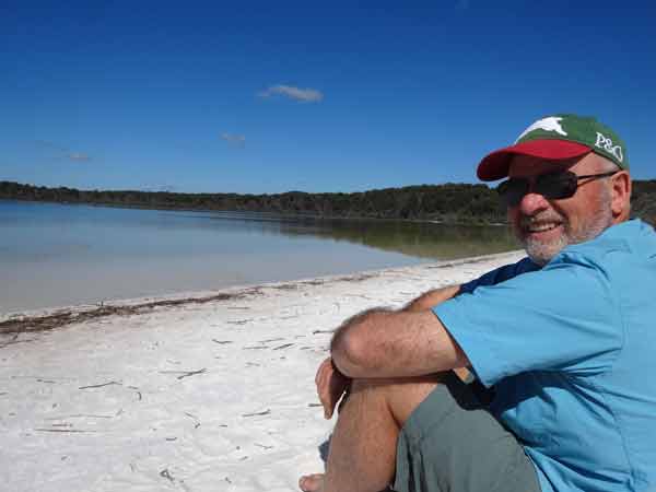 |
| A drone shot of Lake Birrabeen, looking north | Me on the edge of Lake Birrabeen |
There are quite a few cars here, including a backpack tour and some small buses. We walk to the lake and have a look around. Unlike Lake McKenzie which is very blue and clear, this lake is a light tanin colour. I use the drone to get some photos while Estelle plays in the sand. Another brilliant spot. While we don't have a swim, the backpackers are in the water enjoying the relatively warm water.
We leave at 11:00 am and continue on the same track. The track, like most of the ones on the island, is soft sand, but there are sections which have a harder sand base. We skirt the edge of Lake Benaroon. Our next stop is Lake Boomanjin which we reach at about noon.
 |  |
| A drone shot of Lake Boomanjin, looking east towards the ocean | The water on the edge of Lake Boomanjin |
There is a large camping area here which is enclosed inside a dingo proof fence. We go inside as we will have lunch. Again, there are lots of people here, mostly the same backpacker group we saw at the last lake. After lunch we walk the short distance to the lake edge. Here I take some more drone footage and photos and Estelle again has a good play in the sand.
This lake is a much deeper brown colour due to the tanin. We sit around for quite a while before we decide to leave. Back on the road, we continue on the Southern Lakes Road. About 12.5 kilometres along we come to the intersection with Dillinghams Road. This heads back to the north-west and goes to Ungowa on the Great Sandy Strait (western) side of the island. We turn left, presumably still on Southern Lakes Road. After 7 kilometres we come to Dilli Village which is a very low impact eco type resort.
 |  |
| A dingo on the beach, it really was cute | Looking out to sea at our house |
The track goes around the back of the village and comes out on the beach. We turn north and a short while along we see a dingo on the sand right in the middle of the main area where everyone is driving. We stop short of it and it gets up and walks towards us. Right next to my driver's door it plops down on the sand. Very cute looking really.
We get back to the house at about 2:30 pm. As usual, we have to unload the food and drink remains from the car and I wash it. Later I have another walk along the beach. So far we have had almost perfect weather apart from last Monday when it was a bit too windy and cooler.
Tonight we are going to dinner at Happy Valley. Mary decides not to come so she will stay at the house and look after Estelle as Nicole is coming with us. Kelly drives the LandCruiser and we leave while it is still a bit light, but of course we will have to come back in the dark. Neither of us has driven on sand at night, so we will take it easy.
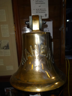 |  |
| The bell of the Maheno | One of two models of the Maheno we see on Fraser Island |
We go to the pub which is a nice, open building. They have some nice beers too! We find that the bell of the SS Maheno is on display and there is a model of the ship here too. It is only then that we realise that in World War I it was HMNZHS Maheno as a hospital ship. She supported Australian and New Zealand troops at Gallipoli in 1915 and 1916. We order dinner, about $22 to $28 for a main, not too bad considering the location. I forget what I had, but it was nice.
Kelly takes it easy coming back along the beach at night. There is little moon as it has not come up yet (it was full about a week ago). A nice night out.
Distance: 75 km
Thursday 2 August 2018 - Fraser Island - Kingfisher Resort
Once again we have a relaxed start to the day as we are only going across the island to Kingfisher Resort. We leave about 11 am and take Cornwells Road from Cornwells Camping Area. We stop at the lookout over Stonetool Blowout and take a photograph of the sand dune. From here we continue to Lake Wabby Road and then Northern Road and once again Cornwells Road.
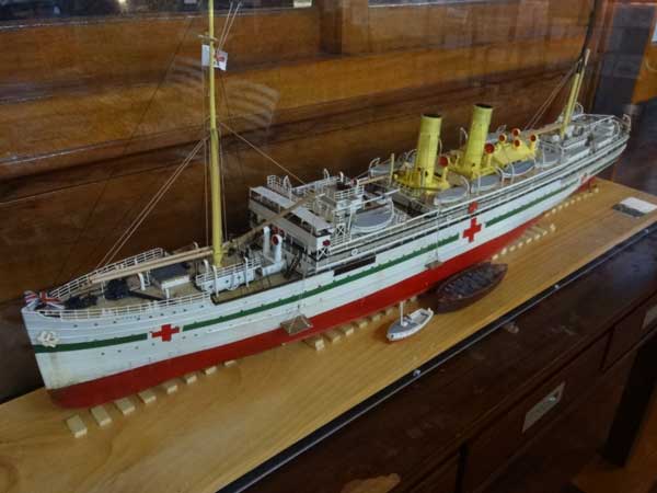
We arrive at Kingfisher Resort a bit after midday. We go to the resort to look at the lunch menu. In the resort lobby there is another model of the SS Maheno. I really do not want a big lunch, I don't really like eating a full meal during the day, so I decide to find something else to eat. Kelly, Nicole and Mary sit down for a proper meal.
 |  |
| The second model of the Maheno | The Stonetool Blowout from the lookout |
I walk around and discover that there is only one option, a pie from the one and only shop. That will do. In fact, it was not bad at all. I walk down to the wharf and have lunch there and take a few photos. We have been here twice before, but on our yacht. We anchored off the beach. After a while I head back to the restaurant and Kelly and the others are almost finished lunch.
 |
| A panoramic photograph of the wharf at Kingfisher Resort. When we sailed past here in 2015 and 2017, we anchored in the middle. |
After they finish, I drive them to the wharf for a look. We then head back to our house, the same way we came. We are back by about 2:00 pm. After, Kelly and I drive back down the beach to the Stonetool Blowout and from the beach I use the drone to video it and take some photographs. We spend the rest of the day here, and I go for another long walk on the beach. As usual, drinks and nibblies overlooking the water and a nice dinner follows.
Distance: 62 km
Friday 3 August 2018 - Fraser Island - Happy Valley and Lake Garawongera
Today is our last full day on the island. We decide to do a trek around the lakes that we have not yet done. We start about We head off about 9 am and drive north to Happy Valley. As we have done on previous days when we went to Eurong, we took our rubbish with us and put it in the dump at Happy Valley. In both places, the dump is located inland of the resort.
Once we have done this, we head inland on the Happy Valley Road. Like all the other inland roads, it is soft sand track. The distance to Lake Garawongera is only nine kilometres, so it does not take long. We stop here and have morning tea. I fly the drone and get some nice shots.
 |  |
| A drone photograph of Lake Garawongera | The Stonetool Blowout from the drone |
While we have morning tea, Estelle once again plays in the sand and in the water. After almost an hour we continue on the track. It is 10.5 kilometres back to the beach at Poyungan Valley. We then head back to Poyungan Rocks for lunch. The rest of the day is spent preparing things for our departure tomorrow, including loading as much as we can into the LandCruiser as we can.
For our last evening, we again have drinks on the balcony. We have had a great time up here, the island really is amazing. Another week would have been great, perhaps staying up north near Orchid Beach, so that we could have explored the northern end a bit better.
Distance: 30 km
Saturday 4 August 2018 - Fraser Island to Surfers Paradise
We are up early as we have a lot to do and a fairly long trip back to Mary's place on the Gold Coast. we have breakfast and load the rest of the food and all our gear into the car. There are plenty of cars heading south, people heading home.
We leave about 8:00 am and drive the almost 50 kilometres back to Hook Point where we have to catch the barge back to Inskip Point. As mentioned, there are plenty of vehicles heading home, we are passed by a few who like to travel a lot quicker than we do (and I do not consider we are slow). There are also a lot coming onto the island.
 |  |
| A drone photograph of the LandCruiser | The LandCruiser on the beach on
the way back to Inskip Point |
The tide is a lot lower now than when we came onto the island last Saturday, so we can drive closer to the water on the harder sand. We only have to wait a short while for the barge to come over as there are two running. However, they wait till it is almost full before leaving for Inskip Point.
Once off the barge we drive to the Inskip Point camping area and stop to reinflate the tyres. We use our compressor (a Supacheap Auto one which is very good and pretty quick). We have morning tea while we wait. From here we drive to Rainbow Beach. We stop for only a short time to do some shopping (something to eat I think). We then drive to Goomboorian which is about 72 kilometres from the barge.
The fuel here I noticed on the way up is 10 cents a litre cheaper than at Rainbow Beach. We refuel, taking 104.2 litres at $1.40 a litre. We have travelled 596 kilometres since we filled up last Saturday at Rainbow Beach, giving an average of 17.5 l/100 km. This means our economy while on Fraser was probably about 19 l/100 km.
We stop on the way back for lunch at Caboolture, arriving at Mary's home about 2:00 pm. We refuel again here, 37.0 litres for 270 kilometres, average 13.7 l/100 km. I also load back in all my dive gear plus some other things to take back home.
Distance: 382 km
Sunday 5 August 2018 - Surfers Paradise to Port Macquarie
Kelly, Nicole and Estelle are flying home this morning from the Gold Coast Airport. Their flight is about 11 am, so we leave Mary's place at 9 am. After dropping them off, I drive to Port Macquarie where I arrive about 4 pm. I stay at the home of our diving buddy, Ian. However, he is not here tonight, so I am hosted by Sharon. We have good evening catching up on the news.
Distance: 478 km
Monday 6 August 2018 - Port Macquarie to Sydney
I leave Sharon's place just after 7 am and head into town and to the river entrance. I want to take some drone footage of the entrance to put on our sailing part of the web site as we have come into the river a few times. I then drive home, getting a good run. I arrive back home at 2:00 pm.
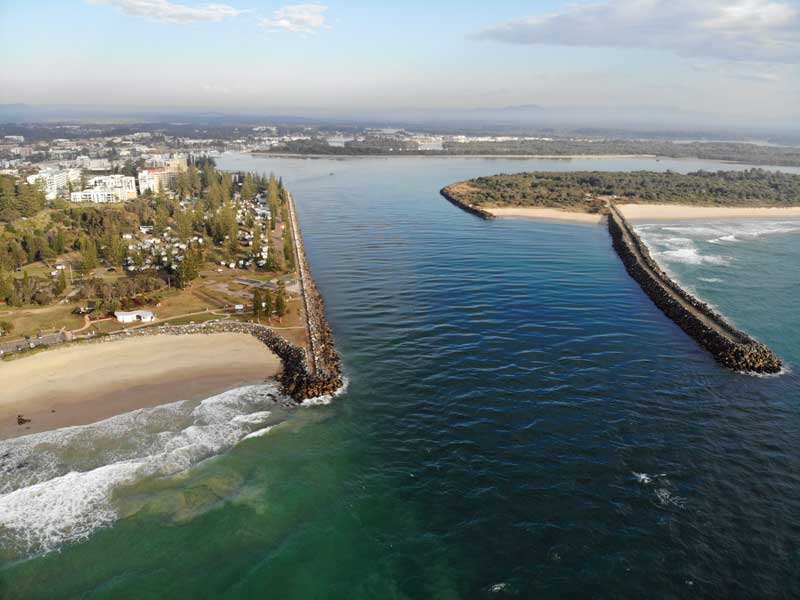 |
| A photograph of the entrance into the Hastings River at Port Macquarie |
For the trip from the Gold Coast to Sydney (plus a bit the next few days) was 896 kilometres. We used 94.9 litres, giving an amazing average of 10.6 l/100 km. I sat on the speed limit the whole way, although there was a lot of roadworks between Grafton and Ballina which had a maximum of 80 km/h.
Distance: 405 km
SUMMARY:
I travelled 3,038 kilometres over the almost two weeks. I used 377.7 litres of diesel, an average of 12.4 l/100 km. I am extremely happy with that economy, considering over 500 km was on sand when the average was 17.5 l/100 km (including some tar back to service station). For one section of the trip, from Grafton to Ballina, I averaged under 9.0 l/100 km, but as I mentioned above, there were roadworks limiting the maximum speed.
We had a great time on the island, so much to see. If you do not want to camp, I can certainly recommend staying in one of the houses, especially the one we had. |  v6.00.307 © 2003-2005

